SoCal communities left with mud, damage after days of wet weather

KABC logo
Last updated: Saturday, December 27, 2025 8:33AM GMT
ABC7 Eyewitness News

After days of storms throughout Christmas week, several Southern California communities are dealing with storm damage from the rain, high winds, flooding and mudslides.

The National Weather Service (NWS) confirmed that an EF-0 tornado touched down in Boyle Heights on Christmas Day, leaving behind damaged roofs, broken windows and debris.

After a historic holiday storm, sunshine and dry conditions are finally returning to Southern California this weekend. But the break from wet weather could be short-lived as more rain is set to arrive New Year's Day.

Dec 22, 2025, 10:13 PM GMT

Malibu residents prepare for possible mudslides ahead of storm

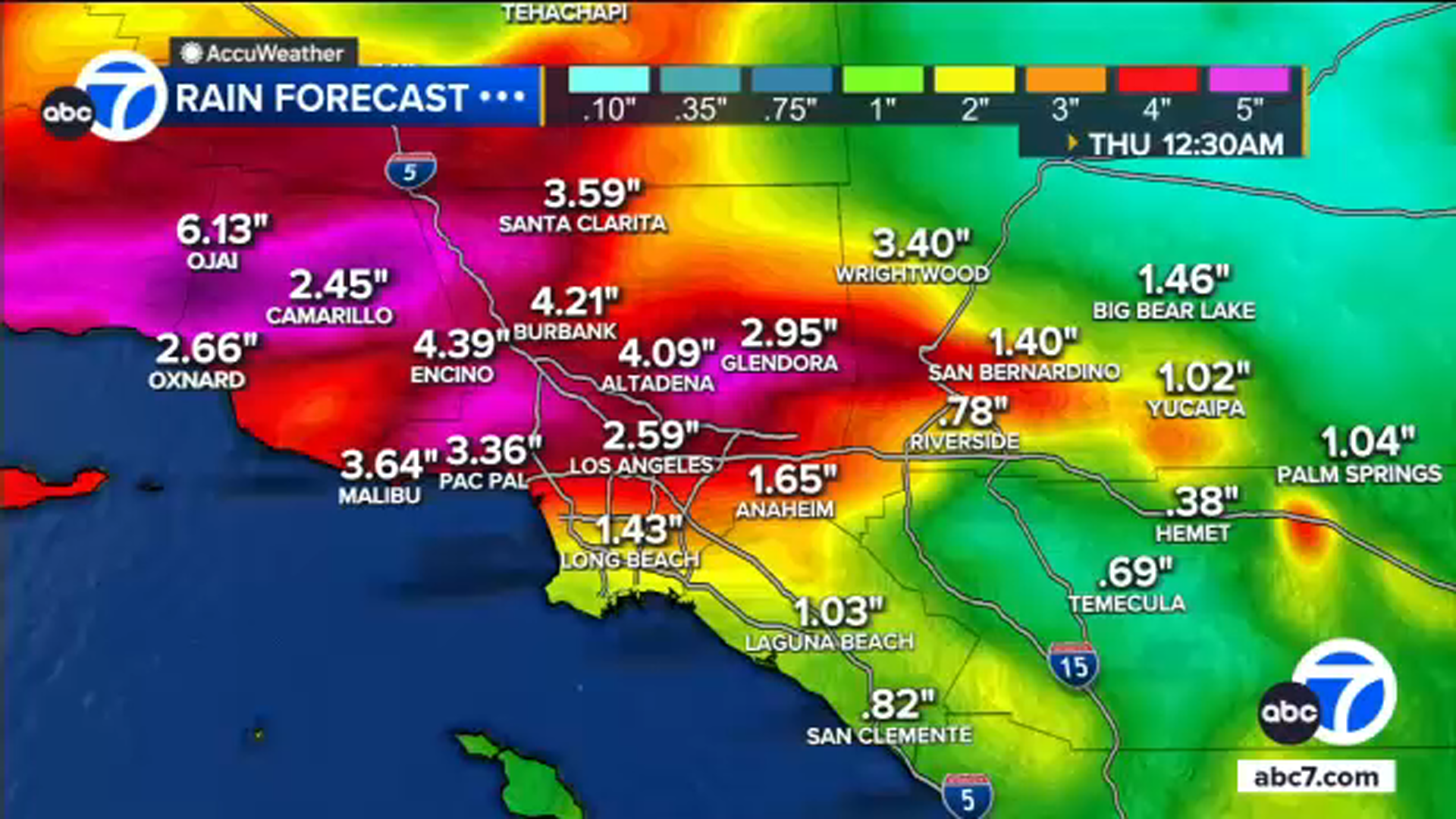
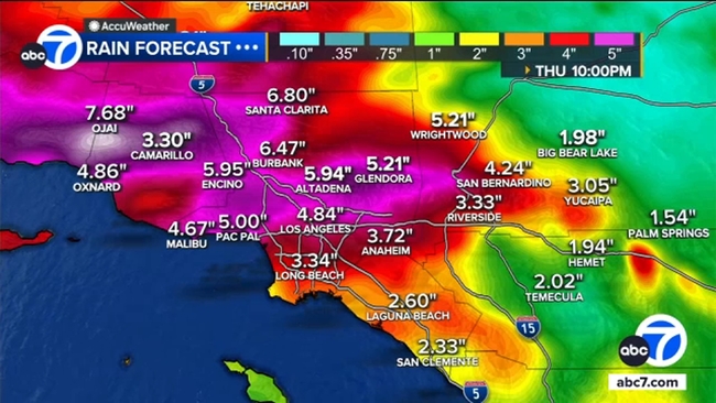
Residents in the Malibu area are bracing for heavy rain as a Christmas week storm is set to arrive in Southern California on Tuesday.

A Flood Watch has been issued for most of the greater Los Angeles area, starting Tuesday at 4 p.m. through Friday at 4 p.m. - and there's a possibility that it could be extended.

"The potential is definitely there for a couple of mudslides and debris flows, particularly in areas that have seen wildfires in recent history," said Kyle Wheeler, a meteorologist for the National Oceanic and Atmospheric Administration.

Residents are being asked to stay vigilant and avoid any unnecessary travel during the storm.

Read more here.

Dec 22, 2025, 10:13 PM GMT

Flash flood watch in places for greater Los Angeles area starting Tuesday

A Flood Watch is in place for most of the greater Los Angeles area starting Tuesday at 4 p.m. through Friday at 4 p.m.

Southern California is preparing for four days of rain expected to begin Tuesday, and the biggest concern is what happens late Tuesday night into Wednesday. That's when rain could fall fast enough to flood streets, overwhelm storm drains and trigger mud or debris flows, especially near hillsides and burn scar areas.

If you live near a hillside, a burn area or a street that floods easily, now is the time to get sandbags, clear storm drains and think about where water tends to go around your home.

Read more here.

Dec 22, 2025, 10:13 PM GMT

Rain totals could reach 10 inches in some SoCal communities

The atmospheric river is expected to drop 0.75 inches to 1.25 inches of rain per hour from Tuesday to Friday.

Some communities could see up to 10 inches of rain.

Rain totals could be be 2 inches to 5 inches, while high totals are likely near burn scars with 4 inches to 8 inches.

The storm is expected to drop moderate-to-heavy rain with brief downpours with flash flooding possible.

Dec 23, 2025, 1:55 AM GMT

Timeline of when atmospheric river storm will hit Southern California

An atmospheric river will bring heavy rain to the Southland, which will be the wettest region in the world during Christmas week. Here's a breakdown of the storm's timing.

An atmospheric river is arriving in Southern California for Christmas. Here's when to expect the rain:

The National Weather Service said an atmospheric river that has been pointed toward Northern California the last few days will shift south and take aim at Southern California on Tuesday.

Rain could start falling as early as Tuesday afternoon. It'll start off scattered and light but intensify, especially overnight, into Wednesday. Less than a half-inch of rain expected is Tuesday evening before the heaviest part of the storm occurs after midnight Tuesday night into Wednesday.

The heaviest rainfall is expected to fall on Christmas Eve, with more rain in the forecast on Christmas Day. While the worst of the storm will likely be Wednesday, periods of rain, possibly heavy at times, are expected on Christmas Day.

The wet weather is expected to stick around through Friday, though the rain chances will begin to decrease.

Moist south to southwest flow will continue to usher in sporadic showers to the area Friday and Saturday, though rain amounts by that time should be under a quarter inch per hour.

Snow is not expected to be a major factor with this event, with levels dropping to around 7,000 feet Thursday and Friday.