

AccuWeather


- Extreme Heat Warning
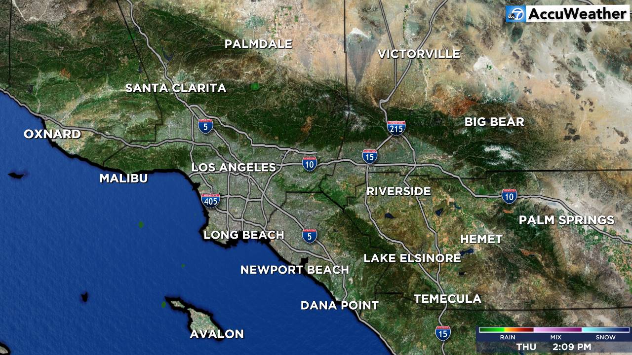
* WHAT...For the Heat Advisory, hot temperatures of 90 to 100 expected. For the Extreme Heat Warning, dangerously hot conditions with temperatures of 95 to 105 expected. * WHERE...Interstate 5 Corridor and Western San Gabriel Mountains and Highway 14 Corridor. * WHEN...For the Heat Advisory, from 10 AM Thursday to 10 AM PDT Friday. For the Extreme Heat Warning, from 10 AM Friday to 8 PM PDT Sunday. * IMPACTS...Heat related illnesses increase significantly during extreme heat and high humidity events. Hot temperatures and high humidity may cause heat illnesses. * ADDITIONAL DETAILS...Heat hazards may extend into next week for portions of the region.More
- Extreme Heat Warning
* WHAT...Dangerously hot conditions with temperatures of 105 to 115 expected. * WHERE...Antelope Valley, Eastern Antelope Valley Foothills, and Western Antelope Valley Foothills. * WHEN...From 10 AM Thursday to 8 PM PDT Sunday. * IMPACTS...Heat related illnesses increase significantly during extreme heat and high humidity events. * ADDITIONAL DETAILS...Heat hazards may extend into next week for portions of the region.More
- Extreme Heat Warning
* WHAT...Dangerously hot conditions with temperatures of 95 to 110 expected. * WHERE...A large portion of southwest California including the coastal ranges and adjacent foothills, as well as the coastal valleys. * WHEN...From 10 AM Friday to 8 PM PDT Sunday. * IMPACTS...Heat related illnesses increase significantly during extreme heat and high humidity events. * ADDITIONAL DETAILS...Heat hazards may extend into next week for portions of the region.More
- Extreme Heat Warning
* WHAT...Dangerously hot conditions with temperatures up to 103 expected. * WHERE...Santa Ana Mountains and Foothills. * WHEN...From 10 AM Friday to 8 PM PDT Sunday. * IMPACTS...Heat related illnesses increase significantly during extreme heat events.More
- Extreme Heat Warning
* WHAT...Dangerously hot conditions with high temperatures mid to upper 90s east of Interstate 5 expected. * WHERE...Orange County Inland Areas. * WHEN...From 10 AM Friday to 8 PM PDT Sunday. * IMPACTS...Heat related illnesses increase significantly during extreme heat events.More
- Coastal Flood Advisory
* WHAT...For the Beach Hazards Statement, 3-6 feet with sets to 7 feet expected. For the Coastal Flood Advisory, minor coastal flooding expected during evening high tides. For the High Surf Advisory, large breaking waves of 5-8 feet with sets up to 9 feet on south-southwest facing beaches and 3-6 feet on west- facing beaches. * WHERE...San Diego County Coastal Areas and Orange County Coastal Areas. * WHEN...For the Beach Hazards Statement, through Wednesday afternoon. For the Coastal Flood Advisory, from 5 PM Wednesday to 3 AM PDT Saturday. For the High Surf Advisory, from 5 PM Wednesday to 5 PM PDT Saturday. * IMPACTS...Flooding of lots, parks, and roads with only isolated road closures expected. Dangerous swimming and surfing conditions and localized beach erosion. Breaking waves can sweep people off jetties and docks, and into dangerous seas. * ADDITIONAL DETAILS...A long period southerly swell (200 degrees) of 3 feet at 17 seconds continues through Wednesday. A higher amplitude swell (from 160-190 degrees) associated with Hurricane Genevieve of around 5 feet at 14 seconds builds late Wednesday into Thursday. Highest surf expected on Thursday and Friday when the swell direction is 180-190 degrees. Swell and associated surf look to subside late Saturday into Sunday.More
- Coastal Flood Advisory
* WHAT...For the Beach Hazards Statement, dangerous rip currents and breaking waves due to elevated surf. For the Coastal Flood Advisory, minor coastal flooding expected. For the High Surf Advisory, large breaking waves of 4 to 8 feet with dangerous rip currents, highest across south facing beaches exposed to southerly swells. * WHERE...Catalina and Santa Barbara Islands. * WHEN...For the Beach Hazards Statement, through Wednesday afternoon. For the Coastal Flood Advisory, from 5 PM Wednesday to 3 AM PDT Saturday. For the High Surf Advisory, from 5 PM Wednesday to 5 PM PDT Saturday. * IMPACTS...Flooding of sea water is likely around the time of high tide, over vulnerable low-lying coastal areas such as parking lots, beaches, and walkways. Significant damage to roads or structures is NOT expected. There is an increased risk for ocean drowning. Rip currents can pull swimmers and surfers out to sea. Large breaking waves can cause injury, wash people off beaches and rocks, and capsize small boats near shore. * ADDITIONAL DETAILS...High tides of 6.2 to near 7.0 feet will occur in the evening hours through Friday night, peaking tonight through Thursday night. In conjunction with the highest expected surf from the Hurricane Genevieve southerly swell, the best potential for minor coastal flooding impacts is expected Wednesday and Thursday evening.More
- Coastal Flood Advisory
* WHAT...For the Beach Hazards Statement, dangerous rip currents and breaking waves due to elevated surf. For the Coastal Flood Advisory, minor coastal flooding expected. For the High Surf Advisory, large breaking waves of 4 to 8 feet with dangerous rip currents, highest across south facing beaches exposed to southerly swells. * WHERE...Ventura County Beaches, Malibu Coast and Los Angeles County Beaches. * WHEN...For the Beach Hazards Statement, through Wednesday afternoon. For the Coastal Flood Advisory, from 5 PM Wednesday to 3 AM PDT Saturday. For the High Surf Advisory, from 5 PM Wednesday to 5 PM PDT Saturday. * IMPACTS...Flooding of sea water is likely around the time of high tide, over vulnerable low-lying coastal areas such as parking lots, beaches, and walkways. Significant damage to roads or structures is NOT expected. There is an increased risk for ocean drowning. Rip currents can pull swimmers and surfers out to sea. Large breaking waves can cause injury, wash people off beaches and rocks, and capsize small boats near shore. * ADDITIONAL DETAILS...High tides of 6.2 to near 7.0 feet will occur in the evening hours through Friday night, peaking tonight through Thursday night. In conjunction with the highest expected surf from the Hurricane Genevieve southerly swell, the best potential for minor coastal flooding impacts is expected Wednesday and Thursday evening.More
- Heat Advisory
* WHAT...For the Heat Advisory, hot temperatures of 90 to 100 expected. For the Extreme Heat Warning, dangerously hot conditions with temperatures of 95 to 105 expected. * WHERE...Interstate 5 Corridor and Western San Gabriel Mountains and Highway 14 Corridor. * WHEN...For the Heat Advisory, from 10 AM Thursday to 10 AM PDT Friday. For the Extreme Heat Warning, from 10 AM Friday to 8 PM PDT Sunday. * IMPACTS...Heat related illnesses increase significantly during extreme heat and high humidity events. Hot temperatures and high humidity may cause heat illnesses. * ADDITIONAL DETAILS...Heat hazards may extend into next week for portions of the region.More
- Heat Advisory
* WHAT...Temperatures of 90 to 100 expected. * WHERE...Eastern San Gabriel Mountains County. * WHEN...From 10 AM Thursday to 8 PM PDT Sunday. * IMPACTS...Heat hazards may extend into next week for portions of the region.More
- Heat Advisory
* WHAT...Temperatures of 85 to 100 expected. * WHERE...A portion of southwest California near the coast including the beaches. * WHEN...From 10 AM Friday to 8 PM PDT Sunday. * IMPACTS...Hot temperatures and high humidity may cause heat illnesses. * ADDITIONAL DETAILS...Heat hazards may extend into next week for portions of the region.More
- Heat Advisory
* WHAT...High temperatures in the mid 80s to lower 90s for higher coastal terrain expected. * WHERE...Orange County Coastal Areas. * WHEN...From 10 AM Friday to 8 PM PDT Sunday. * IMPACTS...Hot temperatures may cause heat illnesses.More
- High Surf Advisory
* WHAT...For the Beach Hazards Statement, 3-6 feet with sets to 7 feet expected. For the Coastal Flood Advisory, minor coastal flooding expected during evening high tides. For the High Surf Advisory, large breaking waves of 5-8 feet with sets up to 9 feet on south-southwest facing beaches and 3-6 feet on west- facing beaches. * WHERE...San Diego County Coastal Areas and Orange County Coastal Areas. * WHEN...For the Beach Hazards Statement, through Wednesday afternoon. For the Coastal Flood Advisory, from 5 PM Wednesday to 3 AM PDT Saturday. For the High Surf Advisory, from 5 PM Wednesday to 5 PM PDT Saturday. * IMPACTS...Flooding of lots, parks, and roads with only isolated road closures expected. Dangerous swimming and surfing conditions and localized beach erosion. Breaking waves can sweep people off jetties and docks, and into dangerous seas. * ADDITIONAL DETAILS...A long period southerly swell (200 degrees) of 3 feet at 17 seconds continues through Wednesday. A higher amplitude swell (from 160-190 degrees) associated with Hurricane Genevieve of around 5 feet at 14 seconds builds late Wednesday into Thursday. Highest surf expected on Thursday and Friday when the swell direction is 180-190 degrees. Swell and associated surf look to subside late Saturday into Sunday.More
- High Surf Advisory
* WHAT...For the Beach Hazards Statement, dangerous rip currents and breaking waves due to elevated surf. For the Coastal Flood Advisory, minor coastal flooding expected. For the High Surf Advisory, large breaking waves of 4 to 8 feet with dangerous rip currents, highest across south facing beaches exposed to southerly swells. * WHERE...Ventura County Beaches, Malibu Coast and Los Angeles County Beaches. * WHEN...For the Beach Hazards Statement, through Wednesday afternoon. For the Coastal Flood Advisory, from 5 PM Wednesday to 3 AM PDT Saturday. For the High Surf Advisory, from 5 PM Wednesday to 5 PM PDT Saturday. * IMPACTS...Flooding of sea water is likely around the time of high tide, over vulnerable low-lying coastal areas such as parking lots, beaches, and walkways. Significant damage to roads or structures is NOT expected. There is an increased risk for ocean drowning. Rip currents can pull swimmers and surfers out to sea. Large breaking waves can cause injury, wash people off beaches and rocks, and capsize small boats near shore. * ADDITIONAL DETAILS...High tides of 6.2 to near 7.0 feet will occur in the evening hours through Friday night, peaking tonight through Thursday night. In conjunction with the highest expected surf from the Hurricane Genevieve southerly swell, the best potential for minor coastal flooding impacts is expected Wednesday and Thursday evening.More
- High Surf Advisory
* WHAT...For the Beach Hazards Statement, dangerous rip currents and breaking waves due to elevated surf. For the Coastal Flood Advisory, minor coastal flooding expected. For the High Surf Advisory, large breaking waves of 4 to 8 feet with dangerous rip currents, highest across south facing beaches exposed to southerly swells. * WHERE...Catalina and Santa Barbara Islands. * WHEN...For the Beach Hazards Statement, through Wednesday afternoon. For the Coastal Flood Advisory, from 5 PM Wednesday to 3 AM PDT Saturday. For the High Surf Advisory, from 5 PM Wednesday to 5 PM PDT Saturday. * IMPACTS...Flooding of sea water is likely around the time of high tide, over vulnerable low-lying coastal areas such as parking lots, beaches, and walkways. Significant damage to roads or structures is NOT expected. There is an increased risk for ocean drowning. Rip currents can pull swimmers and surfers out to sea. Large breaking waves can cause injury, wash people off beaches and rocks, and capsize small boats near shore. * ADDITIONAL DETAILS...High tides of 6.2 to near 7.0 feet will occur in the evening hours through Friday night, peaking tonight through Thursday night. In conjunction with the highest expected surf from the Hurricane Genevieve southerly swell, the best potential for minor coastal flooding impacts is expected Wednesday and Thursday evening.More


