SoCal communities left with mud, damage after days of wet weather

KABC logo
Last updated: Saturday, December 27, 2025 8:33AM GMT
ABC7 Eyewitness News

After days of storms throughout Christmas week, several Southern California communities are dealing with storm damage from the rain, high winds, flooding and mudslides.

The National Weather Service (NWS) confirmed that an EF-0 tornado touched down in Boyle Heights on Christmas Day, leaving behind damaged roofs, broken windows and debris.

After a historic holiday storm, sunshine and dry conditions are finally returning to Southern California this weekend. But the break from wet weather could be short-lived as more rain is set to arrive New Year's Day.

KABC logo
Dec 22, 2025, 11:00 PM GMT

Map shows evacuation warnings, orders for Los Angeles County

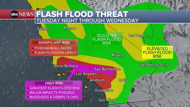
Los Angeles County officials released an interactive map of evacuation warnings as the region braces for a storm that is expected to slam Southern California with heavy rain.

The evacuation warning will be in effect from 11 a.m. Tuesday through 11 p.m. Thursday for the Palisades, Sunset and Hurst burn scar areas.

Evacuation orders are in place for a select number of vulnerable properties. Los Angeles police were going door-to-door, alerting residents at vulnerable addresses.

Here is an interactive map showing the latest evacuation information:

KABC logo
Dec 22, 2025, 10:56 PM GMT

Parts of SoCal upgraded to rare 'high risk' of flash flooding on Wednesday

The National Weather Service (NWS) has upgraded parts of Southern California to "high risk" for excessive rainfall and flash flooding on Christmas Eve.

The greatest risk is across wildfire burn scar areas, with mudslides and debris flows possible.

Portions of Los Angeles, Ventura and San Bernardino counties are facing a significant flash flood threat on Wednesday.

The "high risk" area is just north of the city of Los Angeles and includes places like Burbank, Altadena, Glendale, San Bernardino, Santa Clarita and Thousand Oaks.

The NWS says the threat of widespread, life-threatening flash flooding is increasing in the region. Officials say it's rare to be under a "high risk" level 4/4 storm, with the risk only issued about 4% of days and accounting for one-third of all flood-related fatalities and 80% of all flood-related damages.

Dec 22, 2025, 10:13 PM GMT

Caltrans to close Topanga Canyon Boulevard near Palisades Fire work zone due to storm

Caltrans will close a 3.6-mile stretch of Topanga Canyon Boulevard between Pacific Coast Highway and Grand View Drive due to expected heavy rainstorms and potential debris flows.

The closure for the road, also known at State Route 27, will begin at 9 p.m. Tuesday.

"Caltrans crews will monitor and reassess road conditions daily as long as it is safe to do so," Caltrans said in a statement. "There is no estimated time for reopening SR-27, but it is likely to remain closed at least through Friday."

Pacific Coast Highway will remain open through the Palisades Fire recovery work zone, which is from Sunset Boulevard to Carbon Beach Terrace. Crews will be positioned in areas that are most susceptible to debris flows.

Dec 22, 2025, 10:13 PM GMT

Evacuation warning issued for Pacific Palisades ahead of storm

Officials with the Los Angeles Fire Department issued an evacuation warning on Monday afternoon for residents in the Palisades Fire area from 11 a.m. Tuesday until 11 p.m. Thursday due to the risk of debris flow.

"Houses in the warning area with high risk will be visited by LAPD to issue specific evacuation orders," an LAFD alert stated.

See a list of all evacuation warnings and orders for Los Angeles here.