Timeline of when atmospheric river storm will hit Southern California
An atmospheric river is arriving in Southern California for Christmas. Here's when to expect the rain:
The National Weather Service said an atmospheric river that has been pointed toward Northern California the last few days will shift south and take aim at Southern California on Tuesday.
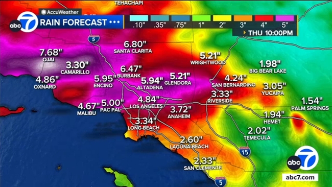
Rain could start falling as early as Tuesday afternoon. It'll start off scattered and light but intensify, especially overnight, into Wednesday. Less than a half-inch of rain expected is Tuesday evening before the heaviest part of the storm occurs after midnight Tuesday night into Wednesday.
The heaviest rainfall is expected to fall on Christmas Eve, with more rain in the forecast on Christmas Day. While the worst of the storm will likely be Wednesday, periods of rain, possibly heavy at times, are expected on Christmas Day.
The wet weather is expected to stick around through Friday, though the rain chances will begin to decrease.
Moist south to southwest flow will continue to usher in sporadic showers to the area Friday and Saturday, though rain amounts by that time should be under a quarter inch per hour.
Snow is not expected to be a major factor with this event, with levels dropping to around 7,000 feet Thursday and Friday.