Cleanup efforts underway across Southern California ahead of another storm
Last updated: Wednesday, November 19, 2025 12:14AM GMT
Efforts are underway across Southern California to clean up downed trees, flooding and rockslides after days of rain, and the rush is on to get it all done before the next storm moves in.
Conditions will dry up somewhat for the next few days, but more rain is on the way to the region this week.
A chance for spotty, light showers will stick around Tuesday morning and afternoon.
Wednesday is expected to be mostly dry before another system arrives and brings even more showers between Thursday and Friday.
Forecasters said that system could drop another quarter to three-quarters of an inch of rain.
Here's everything you need to know about the stormy weather this week:
Key Headlines
Nov 17, 2025, 1:50 PM GMT
Nov 16, 2025, 4:11 AM GMT
Nov 16, 2025, 4:10 AM GMT
Nov 15, 2025, 9:57 PM GMT
Nov 14, 2025, 5:01 PM GMT
Here's how the news is developing.
Nov 14, 2025, 3:42 PM GMT
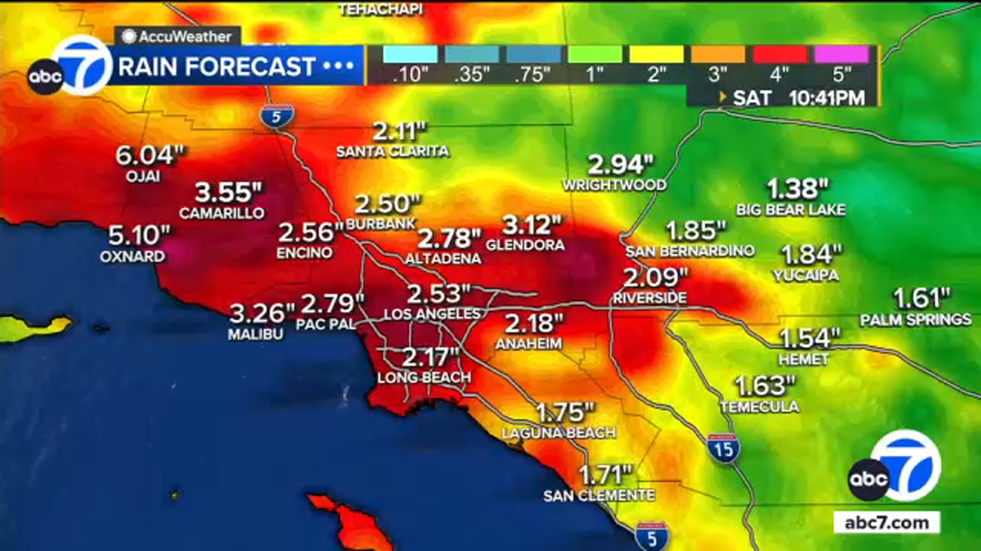
LA area could get more than a months' worth of rain in 24 hours
The greater Los Angeles area could likely see more than a normal November months' worth of rain within a 24 hour period with this storm.
Rainfall totals between now and Saturday evening are projected to be 4-inches but areas with the heaviest storms could see more than that.
On average, the L.A. area records 0.8 inches of rain in the entire month of November, meaning this storm will likely bring more than that. The record for this month in 1965 was 9.68 inches.
Here's a look at expected rainfall totals:
Nov 14, 2025, 2:38 PM GMT
More than 22 million under flood watch in SoCal
More than 22 million people in Southern California are under a flood watch through at least Saturday evening as a storm will bring several rounds of significant rain to the region.
The storm is expected to last through the weekend, elevating the risk for flash flooding, mudslides and debris flows.
Because of that, evacuation warnings are in place for several areas of Southern California.
The greatest risk in burn scar areas will be between 8 p.m. Friday and 3 p.m. Saturday when the the heaviest rain is expected. Rainfall rates could reach 1 inch per hour or great, especially during any thunderstorms.
Nov 14, 2025, 2:02 PM GMT
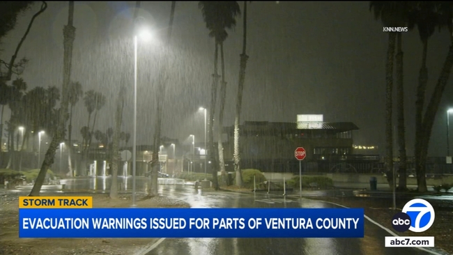
Ventura County seeing bulk of rain
A storm is moving into Southern California and some of the heaviest rain is coming down in Ventura County.
As the area gets hit with rain, there are mudslide and debris flow concerns in the Mountain Fire burn area. Last year's fire devastated neighborhoods in Camarillo Heights.
A storm is moving into Southern California and some of the heaviest rain is coming down in Ventura County.
Evacuation warnings are in place for the burn scar area, as well as Matilija Canyon, through 6 p.m. Sunday.
The county has deployed 40 extra firefighters and three engines in case the hillsides give way.
Nov 14, 2025, 8:41 AM GMT
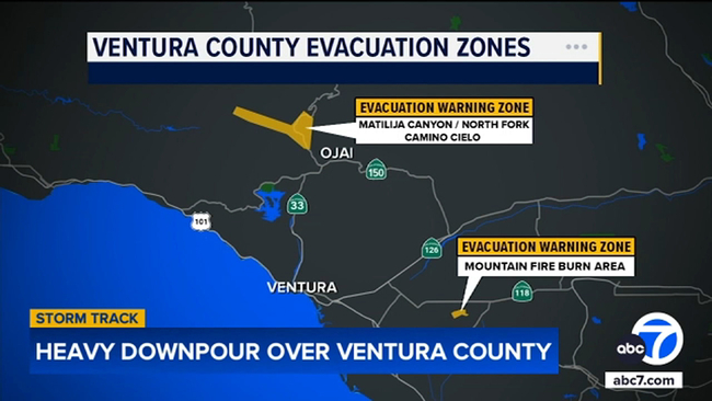
Evacuation warnings issued for parts of Ventura County
Evacuation warnings are in place for the Mountain Fire burn area and the Matilija Canyon, Camino Cielo and North Fork communities in Ventura County. The warning is in effect through 6 p.m. Sunday.
Last year's Mountain Fire devastated neighborhoods in Camarillo Heights. Ventura County has added 40 extra firefighters and three engines just in case hillsides soften and buckle.
"Our concern with this rainstorm is there's a variance in the expectations," said Andrew Dowd with the Ventura County Fire Department. "There's a variance in what the models are looking at, so if we see a heavy downpour, a significant amount of rainfall, especially over a concentrated area we might exceed the debris flow thresholds.
"Right now, the current models show that we will not exceed those debris flow thresholds, but we want to be prepared just in case it happens."
Evacuation warnings are in place for the Mountain Fire burn area and the Matilija Canyon, Camino Cielo and North Fork communities in Ventura County.