Storm timeline: Rain, snow move in across SoCal

An atmospheric river storm has moved into Southern California. It's expected to be stronger and slower (meaning it will last longer), leading to flooding risks, heavy mountain snow and strong winds.
Forecast: Get the latest weather updates here
The National Weather Service called the weather system "the largest storm of the season" and is expecting the storm to have "dangerous, even life-threatening impacts." A number of evacuation orders and warnings have been issued across the region in preparation.
Here's what you need to know about the storm:
When will it rain in Southern California?
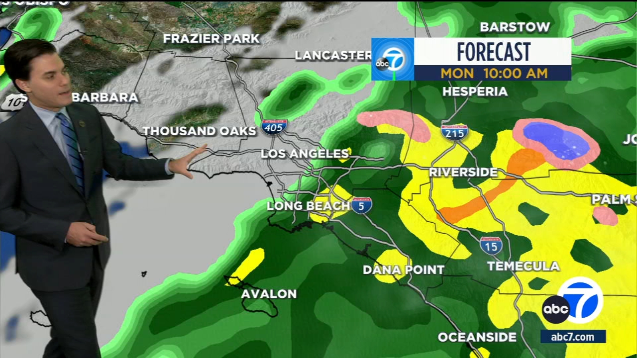
The rain slowly moved into the region from the north Sunday morning, bringing light showers to Ventura County. The storm will only intensify moving forward and is expected to last into Tuesday and Wednesday. The storm system could produce 48 hours of continuous rain.
When will it snow in Southern California mountains?
The snow began Sunday in the mountains. Snow is expected to hit the mountains for most of the week.
Heavy rain is also expected in the area. Flooding is very possible in mountain communities.
Get the latest updates on the weather with the Free ABC7 Los Angeles app
Download the ABC7 app for weather alerts: Click here for iOS devices | click here for Android devices. If you have the app, turn on push notifications and personalize the app. Click on My News from the bottom menu, then star the topics you'd like to follow and tap Done.
What is an atmospheric river and what does it have to do with this storm?
The storm is a combination of a cold front flowing down from Alaska and an atmospheric river pushing across the Pacific.
Atmospheric rivers "typically occur ahead of cold fronts across the Pacific," said National Weather Service forecaster Bob Oravec. "And when they interact with the West Coast topography, you often get some very heavy rain both along the coastal ranges and also inland through the Sierras."
Models suggest the storm could intensify as it approaches the coast of California, a process called bombogenesis in which a spinning low-pressure system rapidly deepens, said Daniel Swain a climate scientist at the University of California, Los Angeles in an online briefing Tuesday. The process is popularly called a bomb cyclone.
How much rain can Southern California see?
"This system will likely produce 24 to 36 hours (or more) of continuous rain," the weather service wrote Thursday in a forecast update.
Los Angeles and Orange counties could see up to 5 inches of rain between Sunday and Tuesday. The valleys and the Inland Empire could see between 3 inches to 7 inches of rain.
In the mountains and foothills, communities could see 6 to 12 inches of rain -- possibly 15 inches.
The high desert could see 2 to 3 inches of rain by Tuesday.
How much snow is expected in the mountain communities?
Mountain communities could see 2 to 4 feet of snow at 6,000 feet elevation.
Live radar: abc7.la/LiveMEGADOPPLER
Why is this storm considered dangerous?
Significant rain and, at higher elevations, snowfall are then expected to hit Southern California from Monday through Wednesday, which could cause mudslides and dangerous flooding.
The most significant threat of flooding is expected on Sunday and Monday.
Ventura and Santa Barbara counties could see the biggest impact from the storm because of flooding. There is a 20% to 25% chance the Ventura River could reach flood stage by Monday due to the back-to-back storms.
The storm is also expected to produce strong winds, with the weather service reminding people to secure all objects outside.
A high surf advisory is also in effect. People are advised to avoid the open ocean.
The NWS advises people to charge batteries and phones in case of outages.
How is California preparing for the storm?
The California Governor's Office of Emergency Services activated its operations center and positioned personnel and equipment in areas most at risk.
Brian Ferguson, the office's deputy director of crisis communications, characterized the situation as "a significant threat to the safety of Californians." He said an area from the state's border with Oregon all the way south to San Diego and from the coast into the mountains could be affected over the next 10 to 14 days.
"This really is a broad sweep of California that's going to see threats over the coming week," Ferguson said.
When will the rain end in Southern California?
Another storm is expected to move into the region Wednesday, which is expected to be much lighter. The rest of the week has rain in the forecast.
See the latest 7-day forecast for your area here.
The Associated Press and City News Service contributed to this report.