Strong winds topple large tree in Sherman Oaks, bring down power lines in Encino


SHERMAN OAKS, LOS ANGELES (KABC) -- Strong winds whipped across Southern California overnight, leaving behind some damage in places like the San Fernando Valley.
The powerful gusts topped a large tree near Noble Avenue and Camarillo Street in Sherman Oaks, forcing that intersection to shut down.
Fortunately the tree did hit a house or cause any other damage. But residents of that neighborhood said it was a frightening evening.
"It was so windy. It was spooky kind of windy," said Sherman Oaks resident Deborah DiBlasio. "It sounded like the house was shaking. Actually couldn't sleep because it was so loud."
Over in Encino, the winds caused power lines to fall.
According to the Los Angeles Department of Water and Power's website, hundreds of customers were temporarily without power near Valley Vista Boulevard and Ventura Canyon Avenue. An outage was also reported in Mission Hills.
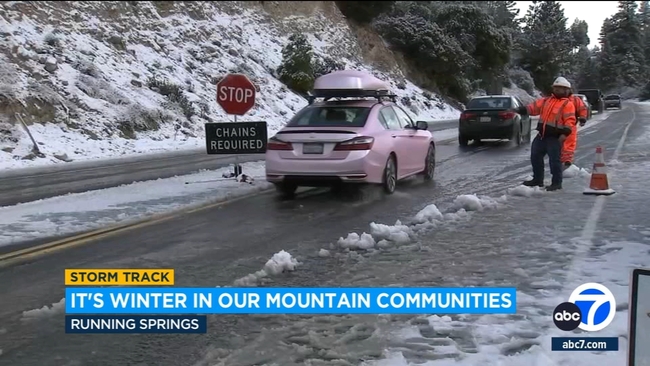
The strong winds, which are expected to continue through Thursday night, come after a cold storm that brought light rain and some snow to mountain communities.
Those strong winds and chilly overnight temperatures are also threatening crops in the Inland Empire, where farmers are taking steps to protect their fruits and vegetables.
The National Weather Service issued a wind advisory that will be in effect until 1 a.m. Friday for the Santa Clarita Valley, Malibu Coast, Los Angeles County beaches, Palos Verdes Hills, Santa Mountains Recreational Area, Calabasas, western San Fernando Valley, the San Gabriel Mountains, Catalina Island and the 14 Freeway corridor.
Forecasters said northwest winds of 20 to 30 mph were expected, along with isolated gusts of 40 to 50 mph.
A more serious high wind warning will be in place for the 5 Freeway corridor until 1 a.m. Friday, impacting areas including the Tejon Pass, Gorman and Pyramid Lake. Those areas could see gusts of up to 65 mph, forecasters said.
"Isolated light snow showers may occur through Thursday morning over the highest elevations adjacent to the Interstate-5 corridor," according to the NWS. "While additional snow accumulations are expected to be less than one inch, the snow would combine with the strong winds to create briefly reduced visibility.''
The unsettled weather system is also expected to again churn up waves along the coast, prompting forecasters to issue a high surf advisory that will be in effect until 3 p.m. Thursday for Los Angeles County beaches. According to the NWS, waves of 4 to 7 feet are anticipated, with some sets reaching 9 feet, accompanied by dangerous rip currents. The most serious impacts are expected on west-facing beaches such as Hermosa, Manhattan Beach and Palos Verdes.
Thursday is expected to be a mostly clear day, albeit windy. Snow could still fall at elevations over 4,000 feet, while temperatures across the area are expected to be in the mid-50s to about 60. Temperatures could drop below freezing in some areas Thursday night.
There will be another slight chance of light rain in the area Saturday night into Sunday morning, with more cold air expected over the weekend, keeping temperatures in the 50s, according to the NWS.
City News Service contributed to this report.