Mountain communities welcome snowfall after relatively dry start to winter ski season


WRIGHTWOOD, Calif. (KABC) -- A cold winter system that created a wet commute for drivers across Southern California Wednesday also brought several inches of snow to the mountains.
Mountain communities that depend on the snow for ski resorts and tourism say the fresh powder was a welcome sight after a relatively dry start to this winter.
"It's beautiful," said Nathan Osborn of Wrightwood. "We've been waiting for the snow to come. We usually get it November-ish. So for it to start dumping like it is now, we are just overjoyed."
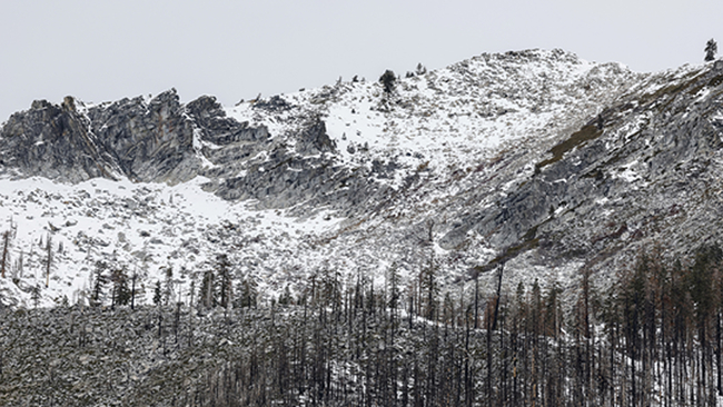
About 2-4 inches of snow fell in the mountains, with lower elevations seeing 1-2 inches.
Drivers were advised to put chains on their tires as they headed up to the ski resorts. Drivers were also advised to be patient with long lines of traffic and slippery conditions on the roads.
The National Weather Service has issued a winter weather advisory that will be in effect through 10 a.m. Thursday for the San Gabriel Mountains and the 5 and 14 freeway corridors.
Forecasters said "moderate" snow is anticipated in the advisory area, with higher mountain elevations possibly receiving as much as 8 inches.
Mountain communities near the Grapevine also saw snow overnight but most of it melted off the 5 Freeway by the morning and traffic was flowing freely throughout the day. The CHP, however, advised motorists to still travel with caution and keep an eye on advisories as more snow is expected.
In fact, by 4 p.m. Wednesday snow was once again falling on the Grapevine.
Grapevine clears up after overnight snowfall - but more is on the way

"There is a 30 percent chance of 1- to 2-inch snow accumulations down to 4,000 feet, including I-5 at Tejon Pass," according to the NWS.
"Snow levels will generally range between 4,500 and 5,000 feet early Wednesday then could fall as low as 4,000 feet late Wednesday into Wednesday night, which could impact I-5 at Tejon Pass."
Such snowfall would impact motorists on the 5 Freeway in the northern reaches of Los Angeles County. Forecasters warned of potential traffic delays or road closures.
On a wider scale, California's first snowpack survey of the year was conducted but it generated very different results from last year's record-breaking report.
The California Department of Water Resources says the water content of the statewide snowpack is only about 25% of average to date following a mostly dry December. The state's snowpack provides about 30% of the water used annually across the state as it melts and runs off into streams and rivers in the spring.
Still, the state's reservoir storage is at 116% of average thanks in part to last year's wet winter, which pulled the state out of a yearslong drought, according to state water officials.
They say it's still very early on in the season and more rain could still be possible.
City News Service contributed to this report.