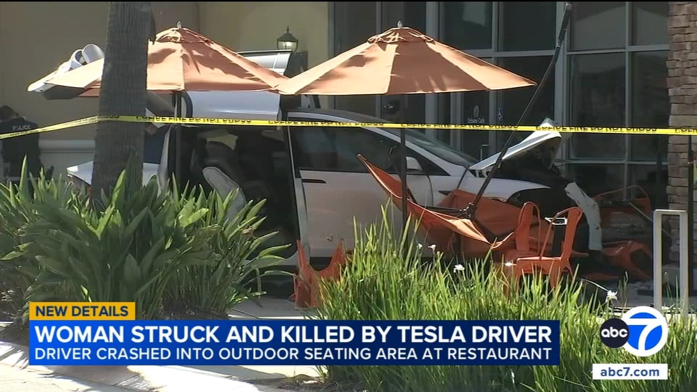
Thomas Fire: List of evacuations, school and road closures in Ventura County


SANTA PAULA, Calif. (KABC) -- The Thomas Fire is leading to thousands of mandatory evacuations as well as road and school closures in Ventura and Santa Barbara counties.
Mandatory evacuations:
Ventura County
-- Residents and day visitors of Rose Valley
-- Boundary of Highway 33 on the north to Casitas Vista Road, northwest to Highway 150, Highway 150 (Casitas Pass Road) west to the 101 Freeway and south on the 101 (including Pacific Coast Highway) to Emma Wood State Beach
-- The area of Hall Road to the west, Sespe Creek to the east, Fillmore City limits to the south, and Los Padres National Forest boundary to the north
-- Ojai: Unincorporated areas west of Ventura River, north of SR 150, east of Casitas Ranger Station, south of Los Padres National Forest
-- Los Encinos Road to Burnham Road, South of SR 150, and the Lake Casitas Recreation Area south of SR 150
-- Entire community of Casitas Springs
-- Ventura: North of Foothill Road from Day Road to Kimball Road.
-- Lake Casitas: North of Highway 150 heading to Highway 33 and south of Los Padres National Forest
-- East Ojai Valley: SR-150 east of Dennison Park to Koenigstein Road, south of Reeves Road
-- Upper Ojai Valley: Highway 150 east of Reeves Road, and unincorporated areas west of Rice Road. Highway 33 north of Fairview Drive. Matilija Canyon
-- Unincorporated area of Fillmore: The area of Hall Road to the west, Sespe Creek to the east, Fillmore City limitsto the south, and Los Padres National Forest boundary to the north
Ventura County Evacuation Map:
Santa Barbara County
-- For the communities of Carpinteria, Montecito and Santa Barbara County, mandatory evacuations are in place from east at Mission Canyon Road to west from SR-150, and north of SR-192 to East Camino Cielo
Santa Barbara County Evacuation Map:
Voluntary Evacuations:
-- Ojai: Casitas Pass Road east to Highway 33, Spring Street to Loma Drive. (Includes Rice Road east to Loma Drive. Baldwin Road north to Besant Road)
-- Unincorporated areas of Fillmore: Sespe Creek to the west, Burson Ranch to the east, Fillmore City limits to the south, and Los Padres National Forest boundary to the north
-- Santa Barbara County: The entire community of Carpinteria and Summerland is under voluntary evacuations from south of SR-192 to the Pacific Ocean. The community of Montecito is under voluntary evacuations from between Highway 101 and SR-192. Portions of Santa Barbara City between SR-192 and S. Salinas Street are under voluntary evacuations
Evacuation Centers:
-- Ventura County Fairgrounds (Mineral Building), 10 W. Harbor Bvld, Ventura
-- Oxnard College gym, 4000 S Rose Ave, Oxnard
-- Santa Paula Community Center
-- UCSB Recreational Center, 516 Ocean Road
-- All animal evacuations are being handled at the Ventura County Fairgrounds located at 10 W. Harbor Blvd, Ventura
School closures:
Latest Ventura County school closures also updated here
-- Briggs Elementary School District - All schools closed Monday and Tuesday
-- Mupu Elementary School District - Closed, will not reopen until Jan. 8
-- Ojai Unified School District - All schools closed, classes will not resume until Jan. 2
-- Santa Paula Unified School District - All schools closed, reopening Dec. 18
-- Thomas Aquinas College - Closed for the rest of the week
-- University Preparation Charter School - Closed for the rest of the week
-- VCOE Career Education Center sites - Camarillo site closed Monday and Tuesday
-- Ventura County Office of Education-operated school sites and classrooms - Closed to students Monday and Tuesday
-- Ventura Unified School District - Closed to students Monday and Tuesday
CSU Channel Islands will remain open, except Goleta campus will be closed the week of Dec. 11.
Road closures
Ojai Valley, Ojai and unincorporated areas
-- SR-150 (Casitas Pass Road) between Santa Ana Road and the 101
-- SR-150 at Santa Ana Road to Via Real
-- SR-150 from Reeves Road to Osborn Road
-- SR-33 northbound at Fairview Road
Ventura and unincorporated areas
North of Foothill Road between Harmon Canyon Road and Hall Canyon Road
North of Poli Street from Hall Canyon Road to Cedar Street
Fillmore and unincorporated areas
-- Old Telegraph Road at C Street
-- Old Telegraph at Keith Road
-- Sycamore Road at SR-126
-- Hall Road at SR 126
Santa Paula unincorporated area
--Cummings Road at Foothill Road
--Peck Road at Foothill Road
--Olive Road at Foothill Road
--Toland at SR-126
-- Timber Canyon at SR-126
-- Briggs at Foothill Road
-- Bridge at SR 126
-- Telegraph Rd at SR126