Live updates: Storm brings flooding, stalled cars near Burbank airport

KABC logo
Last updated: Friday, February 20, 2026 1:04PM GMT
ABC7 Eyewitness News

LOS ANGELES (KABC) -- You may want to keep the rain boots and umbrellas out as the third storm to hit Southern California this week moves into the region Thursday morning, bringing more rain to areas previously affected.

Powerful thunderstorms, wind and rain battered the region just days ago, toppling over trees and leading to water rescues.

Get the latest storm timeline and developments from across the region below:

Brianna Ruffalo  Image
Feb 19, 2026, 8:08 PM

SoCal will soon get a break from wet weather

The third storm of the week is quickly moving into Southern California, bringing more rain and snow, but the region will soon get a break from the wet weather.

Light to moderate rail will continue to move east, with heavy downpours possible at times. Cold temperatures and gusty conditions with potentially damaging winds will remain even after the rain stops.

The widespread rain will begin to taper off by the early afternoon hours as it moves into the Inland Empire.

The third storm of the week is quickly moving into Southern California, bringing more rain and snow, but the region will soon get a break from the wet weather.
KABC logo
Feb 16, 2026, 4:04 AM GMT

Winter Storm Warning issued for some mountain regions with snow storm on the way

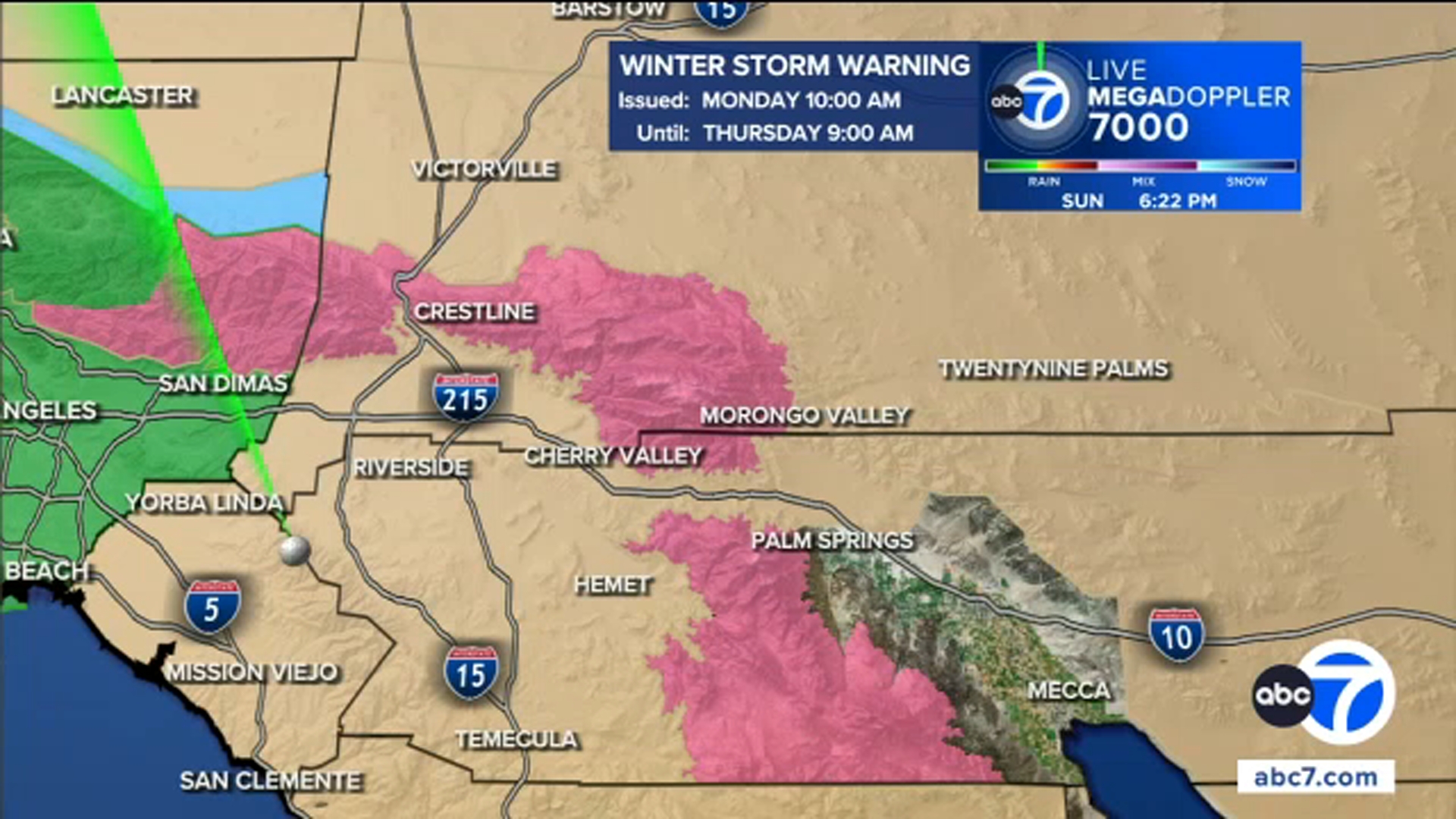
A Winter Storm Warning will be in effect for the northern Ventura County Mountains and eastern San Gabriel Mountains from 10 a.m. on Monday through 9 a.m. on Thursday as Southern California is hit with several powerful winter storms.

Monday alone could bring 3 feet of snow to the highest elevation mountain regions.

A Winter Storm Watch has also been issued from Tuesday at 9 p.m. through Thursday at 9 a.m. for the western San Gabriel Mountains and Highway 14 Corridor, western Antelope Valley foothills, eastern Antelope Valley foothills, Santa Barbara County interior mountains, southern Ventura County mountains and Interstate 5 corridor.

KABC logo
Feb 15, 2026, 7:36 PM GMT

Authorities urging residents to begin storm preps now

A series of powerful storm systems is expected to bring widespread rain to the region beginning overnight, prompting Los Angeles city officials to issue evacuation warnings and urge residents to prepare for potentially hazardous conditions.

A series of powerful storm systems is expected to bring widespread rain to the region beginning overnight.

The city of Los Angeles issued an evacuation warning due to the risk of debris flows for some residents living in several burn scar areas, including the Palisades, Hurst and Sunset fire zones.

The warning goes into effect at 9 p.m. on Sunday and lasts through 9 a.m. Tuesday.

Authorities are urging residents to begin storm preparations immediately.

Recommendations include securing outdoor furniture or lightweight items, keeping an emergency supply bag accessible, and adjusting travel plans when possible to avoid the heaviest rain. Local fire stations are distributing sandbags.

Randy Stoklos, a resident who was able to save his home during the Palisades Fire, said he is preparing for an active week but remains calm.

"I've heard and gotten the warnings that we must kind of make a move and be thoughtful of what kind of rain is coming, and it's seasonable, so I'm not threatened. I think that we're going to get a good soaking and it's going to be a bit of rain," he said.

The storms are expected to continue into Monday, with the city advising residents to stay aware of rapidly changing conditions and follow all official safety guidance.

KABC logo
Feb 15, 2026, 3:02 AM GMT

Evacuation warning issued for possible debris flows in LA burn scar areas

The city of Los Angeles issued evacuation warnings for people living in burn scar areas, after a flood watch was issued for a wide swath of Los Angeles County from Monday morning through Monday evening. Rock and mud slides are possible near steep terrain, and debris flows are possible on burn scars.

Mayor Karen Bass warned residents in those areas to take precautions and be prepared for potential emergency warnings.

"Ahead of heavy rain forecasted this week, first responders, Public Works crews, and city personnel are taking action to keep Angelenos safe and will be ready to respond to any potential impacts," Bass said in a statement late Saturday. "This is likely to be another significant rain event. All Angelenos -- especially those in burn scar areas -- are encouraged to follow official guidance, use caution on the roads, plan ahead, and stay informed."

The warning goes into effect at 9 p.m. on Sunday and lasts through 9 a.m. Tuesday.

See the map of impacted areas here:

KABC logo
Feb 15, 2026, 3:13 AM GMT

Stretch of Topanga Canyon Boulevard to close ahead of storm

Storm preparations are already happening ahead of the round of storms set to arrive on Monday.

Caltrans will close a 3.5-mile stretch of Topanga Canyon Boulevard starting at 10 p.m. on Sunday from Pacific Coast Highway up to Grand View Drive.

This has become a common occurrence before recent storms due to fear of mud and debris slides in the Palisades Fire burn zone.

The closure is expected to last through at least Tuesday morning.