Live updates: Storm brings flooding, stalled cars near Burbank airport

KABC logo
Last updated: Friday, February 20, 2026 1:04PM GMT
ABC7 Eyewitness News

LOS ANGELES (KABC) -- You may want to keep the rain boots and umbrellas out as the third storm to hit Southern California this week moves into the region Thursday morning, bringing more rain to areas previously affected.

Powerful thunderstorms, wind and rain battered the region just days ago, toppling over trees and leading to water rescues.

Get the latest storm timeline and developments from across the region below:

Brianna Ruffalo  Image
Feb 19, 2026, 8:08 PM

SoCal will soon get a break from wet weather

The third storm of the week is quickly moving into Southern California, bringing more rain and snow, but the region will soon get a break from the wet weather.

Light to moderate rail will continue to move east, with heavy downpours possible at times. Cold temperatures and gusty conditions with potentially damaging winds will remain even after the rain stops.

The widespread rain will begin to taper off by the early afternoon hours as it moves into the Inland Empire.

The third storm of the week is quickly moving into Southern California, bringing more rain and snow, but the region will soon get a break from the wet weather.
Abigail Velez Image
Feb 16, 2026, 7:32 AM GMT

Topanga Canyon businesses brace for storm as road closures disrupt access

Parts of Topanga Canyon Boulevard were shut down Sunday night ahead of an incoming winter storm, leaving local businesses preparing for disruptions.

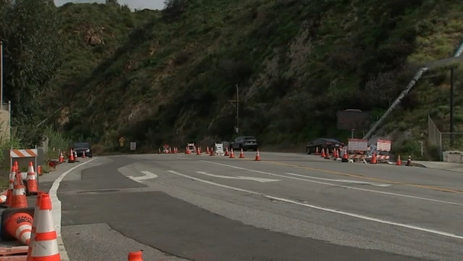
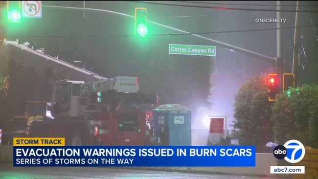
Parts of Topanga Canyon Boulevard were shut down on Sunday night as officials warn of possible rock slides and debris flows ahead of an incoming winter storm, leaving local businesses preparing for another round of disruptions.

The roadway is a major connector between the San Fernando Valley and the coast, but residents and business owners say closures have become more common since last year's fires weakened sections of the canyon.

Michael Levine, the owner of Monty's on Topanga Canyon Boulevard, said he is remaining optimistic despite the storm forecast. When asked if he was worried about flooding, he said, "No, I got a new roof. We used to have all kinds of leaks. It's an old building, built in the 70s."

After decades in business, Levine said he has weathered many storms in the canyon.

"We're going through floods in Topanga. How would you like to have the storms on the East Coast? We all get through it," Levine said.

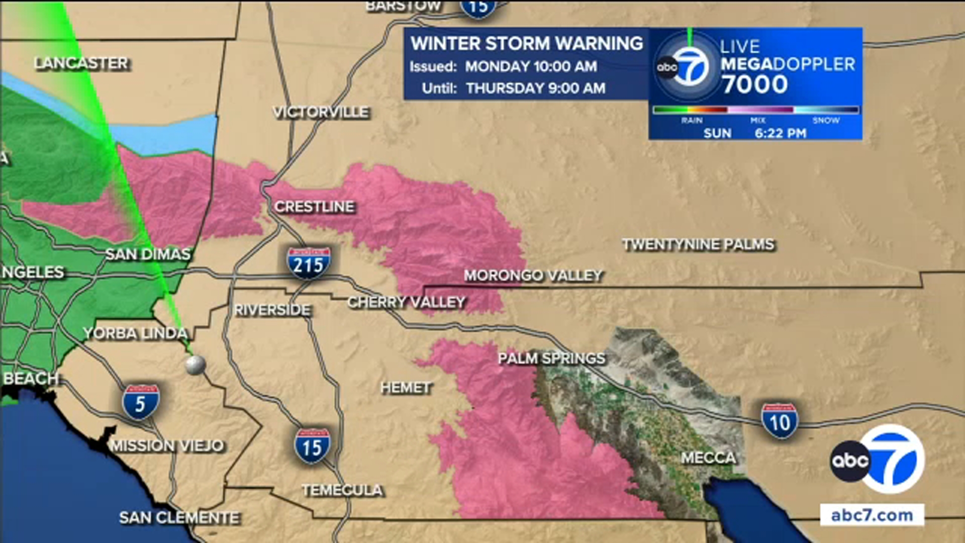
Officials routinely shut down vulnerable areas of Topanga Canyon Boulevard when heavy rain is expected, citing the risks of mudslides, falling rocks and debris. This latest closure stretches from Pacific Coast Highway to Grand View Drive.

"When they shut Topanga down, or any road down, cars go everywhere else, so it increases traffic," Levine said. "It's not just shutting off the road."

For coastal residents, Topanga Canyon Boulevard is one of the most direct routes into the Valley. With the lower canyon closed, the drive to businesses like Monty's is much more difficult. Still, Levine said he is confident customers will find their way.

"But as far as business goes, if people want to eat, they're going to come out," Levine said.

Closer to the coast, other business owners say the repeated closures have already taken a toll.

"We've been dealing with the road closures for some months now, especially after the fires, so it has drastically affected our business, and a lot of other owners in the area," said Pauline Cohn, the co-owner of Cafe Mimosa.

With strong winds and heavy rain expected across the region, officials are urging residents -- particularly those in the burn scar areas -- to prepare for flooding and debris flows.

Topanga Canyon Boulevard will remain closed until crews can inspect the roadway and determine it is safe to reopen, which officials say may not happen until after the storm passes.

Abigail Velez Image
Feb 16, 2026, 7:24 AM GMT

Pacific Palisades residents prepare as officials warn of mud and debris flow risk

Residents living in and around recent burn scar areas in the Pacific Palisades are preparing for heavy rain.

Residents living in and around recent burn scar areas in the Pacific Palisades are preparing for heavy rain expected overnight, with officials urging people to be ready for possible evacuations.

In the Palisades fire zone, a portion of Topanga Canyon Boulevard was closed on Sunday night as the storm approached. City and county officials say the combination of saturated hillsides and firedamaged terrain increases the risk of mud and debris flows.

"We seem to be in nature's spotlight lately," resident Will Adams said as neighbors made storm preparations across the Palisades.

Forecasters warn the incoming system could be the strongest storm of the season, bringing heavy rain, strong winds and a threat of flash flooding. Officials are advising residents to secure outdoor items, gather emergency supplies and prepare for possible power outages.

"Given the fires, I should have a better plan, but I don't," Adams said. "But my wife always has a plan, so I'll rely on her."

Similar preparations were underway in Altadena, where residents near burn scar areas picked up sandbags and stocked up ahead of the storm.

Authorities announced road closures on Topanga Canyon Boulevard due to the risk of mudslides, falling rocks and debris.

"We must kind of make a move or be thoughtful about what kinda rain is coming," a Pacific Palisades resident said. "It's seasonable, so I'm not threatened. I think we're going to get a good soaking and a bit of rain."

The heaviest rainfall is expected on Monday morning and afternoon. Officials are urging people in burn scar areas to stay alert, have an emergency plan and be prepared to leave if evacuation orders are issued.

KABC logo
Feb 16, 2026, 4:04 AM GMT

Winter Storm Warning issued for some mountain regions with snow storm on the way

A Winter Storm Warning will be in effect for the northern Ventura County Mountains and eastern San Gabriel Mountains from 10 a.m. on Monday through 9 a.m. on Thursday as Southern California is hit with several powerful winter storms.

Monday alone could bring 3 feet of snow to the highest elevation mountain regions.

A Winter Storm Watch has also been issued from Tuesday at 9 p.m. through Thursday at 9 a.m. for the western San Gabriel Mountains and Highway 14 Corridor, western Antelope Valley foothills, eastern Antelope Valley foothills, Santa Barbara County interior mountains, southern Ventura County mountains and Interstate 5 corridor.

KABC logo
Feb 15, 2026, 7:36 PM GMT

Authorities urging residents to begin storm preps now

A series of powerful storm systems is expected to bring widespread rain to the region beginning overnight, prompting Los Angeles city officials to issue evacuation warnings and urge residents to prepare for potentially hazardous conditions.

A series of powerful storm systems is expected to bring widespread rain to the region beginning overnight.

The city of Los Angeles issued an evacuation warning due to the risk of debris flows for some residents living in several burn scar areas, including the Palisades, Hurst and Sunset fire zones.

The warning goes into effect at 9 p.m. on Sunday and lasts through 9 a.m. Tuesday.

Authorities are urging residents to begin storm preparations immediately.

Recommendations include securing outdoor furniture or lightweight items, keeping an emergency supply bag accessible, and adjusting travel plans when possible to avoid the heaviest rain. Local fire stations are distributing sandbags.

Randy Stoklos, a resident who was able to save his home during the Palisades Fire, said he is preparing for an active week but remains calm.

"I've heard and gotten the warnings that we must kind of make a move and be thoughtful of what kind of rain is coming, and it's seasonable, so I'm not threatened. I think that we're going to get a good soaking and it's going to be a bit of rain," he said.

The storms are expected to continue into Monday, with the city advising residents to stay aware of rapidly changing conditions and follow all official safety guidance.