Cleanup efforts underway after storm dumps heavy rain across SoCal; multiple evac orders lifted

KABC logo
Last updated: Wednesday, October 15, 2025 4:20PM GMT
ABC7 Eyewitness News

Cleanup efforts were underway Wednesday across Southern California following a rare October storm that brought significant rain to the region.

There had been concerns of mud flows in the burn scar areas of the January wildfires, but major flooding damage was avoided for the most part.

Some spots continued to see showers overnight, keeping roads slick and creating dangerous driving conditions.

Evacuation warnings were in place for the Eaton Fire burn scar area due to the possibility of mud or debris flows.

All evacuation orders and warnings were lifted within the Pacific Palisades, Sunset, and Hurst burn scar areas as of 6 p.m.

Evacuation orders for Trabuco Creek, Hot Springs Canyon, Bell Canyon, Long Canyon and Modjeska Canyon were also lifted at 5 p.m.

You can find more information at AlertLA.org.

KABC logo
Oct 13, 2025, 10:23 PM GMT

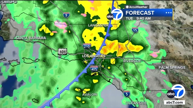
Evacuation warning issued for Eaton burn scar area ahead of storm

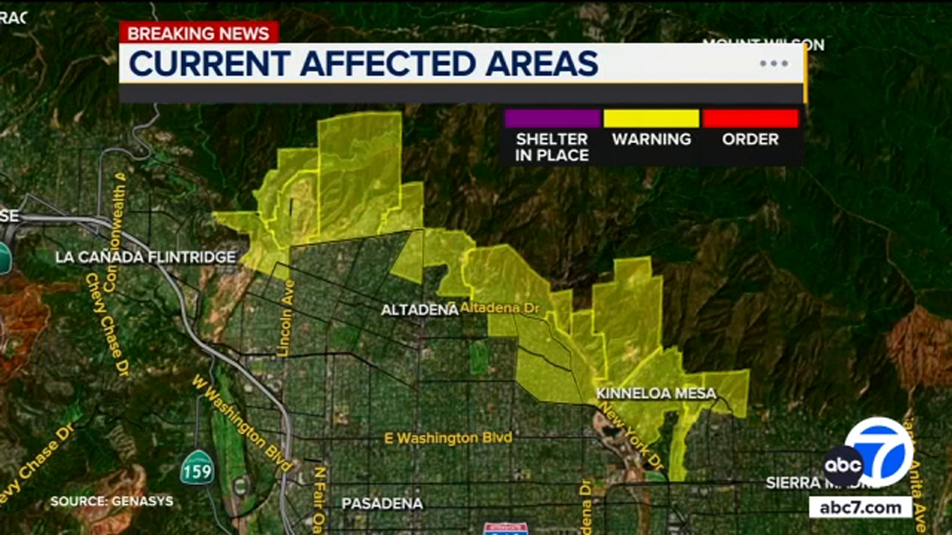
An evacuation warning was issued for the Eaton Fire burn scar area on Monday afternoon due to the possibility of mud or debris flows with showers headed to Southern California, according to the Los Angeles County Sheriff's Department.

Neighbors near the San Gabriel Foothills in Altadena are being asked to get set for possible evacuations. Residents should gather loved ones, pets and supplies.

Those who may need more time evacuating should consider leaving now, the sheriff's department warned.

An evacuation warning is issued when there is a potential threat to life and/or property. An evacuation order is issued when there is an immediate threat to life and property, and it is a lawful order to leave right away. After an evacuation order is issued, the area is lawfully closed to public access, and residents are considered in danger if they stay.

You can find more information at AlertLA.org

KABC logo
Oct 14, 2025, 6:20 AM GMT

Heavy rain moves into SoCal, with showers expected all day Tuesday

A significant amount of rain is in the forecast for Southern California on Tuesday, triggering a flash flood watch for much of the region.

A significant amount of rain is in the forecast for Southern California this week, triggering a flash flood watch for much of the region.

With the impending rain, there is concern for the burn scar areas from the January wildfires, especially in and around Altadena. About 1.5 inches of rain are forecasted in the Pacific Palisades, and nearly 3 inches are forecasted in Altadena.

A system moving into the greater Los Angeles area on Monday night is expected to bring a total of 1.5 to 3 inches of rain by Wednesday morning.

By 10 or 11 p.m. Monday, areas north of Los Angeles County will see the rain first. Then, overnight and into the morning hours, expect widespread, heavier rain throughout the area, with stronger showers in the Eaton Fire burn scar areas between 5 and 10 a.m.

Light to moderate rain will stick around all day on Tuesday. The system also brings the possibility of thunderstorms, hail and strong rotating winds, meaning we could see some tornadic activity on Tuesday.

Overnight into Wednesday, the showers should calm down, with the last of the rain moving east by Wednesday morning.