Cleanup efforts underway after storm dumps heavy rain across SoCal; multiple evac orders lifted

KABC logo
Last updated: Wednesday, October 15, 2025 4:20PM GMT
ABC7 Eyewitness News

Cleanup efforts were underway Wednesday across Southern California following a rare October storm that brought significant rain to the region.

There had been concerns of mud flows in the burn scar areas of the January wildfires, but major flooding damage was avoided for the most part.

Some spots continued to see showers overnight, keeping roads slick and creating dangerous driving conditions.

Evacuation warnings were in place for the Eaton Fire burn scar area due to the possibility of mud or debris flows.

All evacuation orders and warnings were lifted within the Pacific Palisades, Sunset, and Hurst burn scar areas as of 6 p.m.

Evacuation orders for Trabuco Creek, Hot Springs Canyon, Bell Canyon, Long Canyon and Modjeska Canyon were also lifted at 5 p.m.

You can find more information at AlertLA.org.

Brianna Ruffalo  Image
Oct 14, 2025, 7:05 PM GMT

Rain not letting up yet. Here's the wet weather timeline

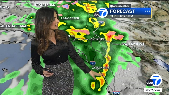
A wild fall storm continues to drench Southern California Tuesday as heavy rain triggered flash flood watches and warnings for parts the region.

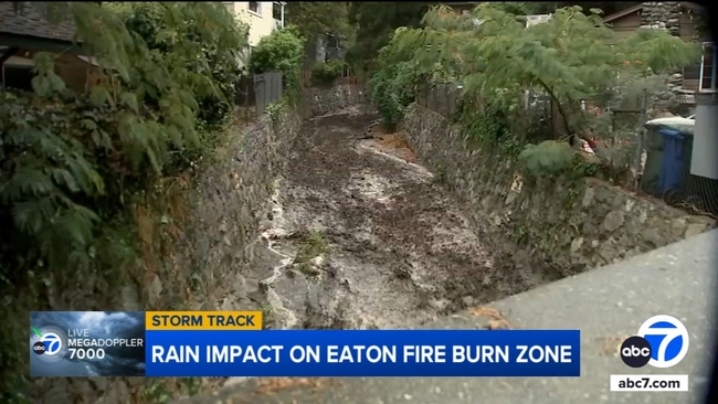
Both Eaton and Palisades fire burn areas received heavy rain Tuesday morning. About 1.5 inches of rain is forecasted in the Pacific Palisades, and as much as 4 inches are forecasted in the hills above Altadena near the Eaton Fire area.

Pockets of heavy rain will persist through the early afternoon hours across L.A. County, in the foothills, the Inland Empire as well as San Diego County.

By later in the afternoon and early evening, the rain will become scattered and light for most of the Southland.

Shower activity is expected pick up a bit Tuesday night, with heavier cells popping up around 11 p.m. But that will ease up heading into Wednesday, which will be mostly clear.

MORE: Get your latest forecast here

A strong fall storm continues to drench Southern California Tuesday as consistent and heavy rain triggered flash flood watches and warnings for parts the region.
Leo Stallworth Image
Oct 14, 2025, 7:51 PM GMT

Heavy rain in Los Angeles leads to dangerous commute

As a storm slammed the Los Angeles area Tuesday with heavy rain, roads became flooded - creating dangerous conditions for drivers.

Slick roads on the 5 Interstate led to a crash where a car turned over on its side.

Drivers drove through flooded roadways during their morning commute.

As a storm slammed the Los Angeles area Tuesday with heavy rain, roads became flooded - creating dangerous conditions for drivers.
Sid Garcia Image
Oct 14, 2025, 7:29 PM GMT

A look at the rain impact on Eaton Fire burn zone

Residents and city officials in Sierra Madre remained on alert Tuesday morning as a strong storm passed through the area, dumping heavy rain at times.

The city was under an evacuation warning due to the potential of damaging mudslides and debris flows during the storm.

Video shows a steady flow of water at the Sierra Madre Canyon Wash, but it did not look deep enough to pose a risk to nearby homes.

Residents and city officials in Sierra Madre remained on alert Tuesday morning as a strong storm passed through the area.

Laura Aguilar, with the city of Sierra Madre, said they were still encouraging residents to exercise caution.

"There have been some significant rainfalls overnight that created some mud and debris flows in our canyon areas.. Those are the areas that are mostly impacted by the burn scar from the Eaton Fire that burned our hillsides earlier this year. So we've asked the residents to evacuate or shelter in place."

KABC logo
Oct 14, 2025, 6:05 PM GMT

Mandatory evacuation order issued for Airport Fire burn scar area in OC

A mandatory evacuation order was issued Tuesday morning for the Airport Fire burn scar area in Orange County as a major storm prompted fears of possible mudflows and flash flooding.

The order went into effect at 10 a.m. for Trabuco Creek, Bell and Hot Springs Canyons due to possible debris flows, according to ocgov.com. The mandatory evacuation zone included the RC Airport, fire station, campground/park and school; Starr Ranch; and Hot Springs Canyon including Lazy-W Ranch.

Meanwhile, Modjeska and Long canyons remained under voluntary evacuation warnings.

The National Weather Service issued a flash flood watch for the burn scar area from 11 a.m. through 5 p.m. as a major storm marched across the region.

Anyone with disabilities and those with access and/or functional needs requiring evacuation assistance were urged to call the Orange County Sheriff's Department Dispatch at (714) 647-7000.

To report storm-related issues with a County road or flood control channel, call the Orange County Public Works Storm Center at (714) 955-0333 during flash flood events and emergencies when OC Public Works' Department Operations Center is activated.

OC Animal Care at 1630 Victory Road in Tustin was accepting dogs, cats and other small pets for people under evacuation orders. A large animal shelter was established at the Orange County Fair Grounds, 88 Fair Drive in Costa Mesa.

Trabuco Canyon's O'Neill Regional Park was also closed due to the storm.