Cleanup efforts underway after storm dumps heavy rain across SoCal; multiple evac orders lifted

KABC logo
Last updated: Wednesday, October 15, 2025 4:20PM GMT
ABC7 Eyewitness News

Cleanup efforts were underway Wednesday across Southern California following a rare October storm that brought significant rain to the region.

There had been concerns of mud flows in the burn scar areas of the January wildfires, but major flooding damage was avoided for the most part.

Some spots continued to see showers overnight, keeping roads slick and creating dangerous driving conditions.

Evacuation warnings were in place for the Eaton Fire burn scar area due to the possibility of mud or debris flows.

All evacuation orders and warnings were lifted within the Pacific Palisades, Sunset, and Hurst burn scar areas as of 6 p.m.

Evacuation orders for Trabuco Creek, Hot Springs Canyon, Bell Canyon, Long Canyon and Modjeska Canyon were also lifted at 5 p.m.

You can find more information at AlertLA.org.

Leticia Juarez Image
Oct 14, 2025, 1:02 AM GMT

IE mountain communities brace for storm just weeks after mudslide

The same San Bernardino County communities impacted by mudslides four weeks ago are bracing for more weather and the potential for flash flooding.

Just about four weeks ago, mudslides triggered by heavy rain impacted several communities in the San Bernardino mountains, including Forest Falls.

Now, those same communities are bracing for more weather and the potential for flash flooding.

The Oak Restaurant in Angeles Oaks serves up more than hot meals. It's also a community lifeline.

"We are the go-to place for our town. So, information, anything people need, and we like to be here, we don't like to leave people hanging," said Monica Aguilar with The Oak Restaurant.

That promise not to leave people hanging is why Aguilar is closing early on Monday -- not to go home, but to stock up before the storm.

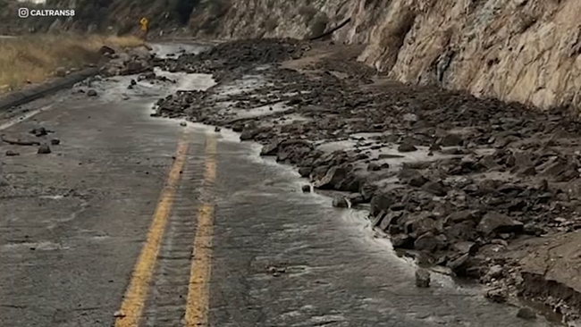
Three weeks ago, when Highway 38 washed out and people were stranded, her restaurant became their refuge.

Customer Esther Gomez remembers how quickly the last storm turned dangerous.

"The last time, lots of mud came down, and my husband has to use a tractor to get the mud out of the side of our house," Gomez said.

With flash flood warnings, Aguilar is preparing for a repeat, making sure The Oak can stay open, even if the road doesn't.

"We heard the warnings last time, and we're getting them again, so, you know, we're just getting ready," Aguilar said.

San Bernardino County Public Works is also staging heavy equipment in the same areas impacted during September's flash flooding.

In Forest Falls, the channel that overflowed and destroyed part of Orrin Richey's home is now cleared, and a new channel now runs alongside a home that was destroyed by the mudslides.

"A few hours after the flood, immediately, you hear the loaders coming and going. They bring in the big trucks, they take the dirt out, they dump it at the county yard -- they're also staged here in Forest Falls," said Debbie Welch, a longtime resident and unofficial mayor of Forest Falls.

Welch says with another round of heavy rain on the way, she'll follow the same advice she gives her neighbors.

"Do your errands early. Get home. Be aware, and plan if you are stuck, to be stuck on either side of whichever creek you are on for a couple hours," Welch said.

If residents do get stuck down the hill, they know Welch will take care of their animals.

"So, one of my organizations is called F.F.A.R.T. (Forest Falls Animal Rescue Team), and what we do is, if you get stuck on the other side of the mountain, we are prepared to go in and take care of your animals," she said.

The flash flooding warning goes into effect at 5 a.m. on Tuesday.

KABC logo
Oct 13, 2025, 11:56 PM GMT

K-rails installed to protect Eaton burn scar areas most at risk

Concerns are growing for the communities surrounding the burn scars of the January wildfires as rain heading to the area could bring dangerous flooding.

Storm preparation is underway as heavy rain on Tuesday could trigger flash flooding, mudslides and debris flows in the Eaton Fire burn zone.

The area is expected to get about two to three inches of rain on Tuesday.

Over the weekend, the City of Pasadena installed K-rails -- or temporary concrete traffic barriers -- to protect parts of the community that are most at risk for mud and debris flows.

The biggest concern is for the homes at the bottom of Eaton Canyon.

According to Los Angeles County Public Works, homeowners have already been notified about potential evacuations due to flooding and debris flows.

A storm like this isn't an afterthought for officials. Over the summer, crews removed tons of material from the Eaton Wash Dam in the foothills of Altadena and Pasadena to prepare for storm season.

"We're asking people to stay off the roads if you can," said Kerjon Lee, a spokesman for Los Angeles County Public Works. "Stay away from mountain roads especially. Mud, debris flow is a concern.

"We're not expecting a lot of rain with this upcoming storm. It's going to be short bursts," Lee said. "But we do want to have the public prepared."

Residents are encouraged to map out an alternate route, as roads may be impacted depending on how much rain comes down.

Sandbags are free and available for residents outside city and county fire stations.

KABC logo
Oct 13, 2025, 11:28 PM GMT

Evacuation warning issued for OC residents along or near Airport Fire burn scar

Effective Monday at 7 p.m., an evacuation warning will be in place for areas along or near the Airport Fire burn scar in Orange County.

The area includes those in Trabuco Creek, Hot Springs Canyon, Bell Canyon, Long Canyon and Modjeska Canyon.

The National Weather Service has issued a Flood Watch for the burn scar area for Tuesday, October 14, from 5 a.m. to 5 p.m. for the expected rain event.

Canyon residents are strongly encouraged to prepare and voluntarily evacuate by 7 p.m. Monday, especially those with disabilities, access and/or functional needs and canyon residents with large animals.

Any person requiring evacuation assistance should call Orange County Sheriff's Department Dispatch at 714-647-7000.

The county said soft road closures may be in place in the Canyon locations, particularly in Trabuco Creek and Modjeska Canyon near the Airport Fire burn scar.

Depending on the conditions, the evacuation warning could be changed to an evacuation order with little or no notice.

Starting at 7 p.m., a shelter will be located at the Foothill Ranch Library Program Annex, which is directly adjacent to the Foothill Ranch Library located at 27002 Cabriole Way, Foothill Ranch, CA 92610.

Read more at ocgov.com.

KABC logo
Oct 13, 2025, 10:45 PM GMT

Evacuation warning issued for Palisades burn scar area ahead of storm

The burn scar area from the January Palisades Fire is under an evacuation warning due to the possibility of flooding and debris flows.

According to the Los Angeles Fire Department, police officers will go door-to-door to visit each high-risk home with additional information.

Other areas under an evacuation warning include the Hurst Fire in Sylmar and the Sunset Fire in the Hollywood Hills.

The National Weather Service is advising residents to remain indoors and be extra careful when driving.

An evacuation warning is issued when there is a potential threat to life and/or property. An evacuation order is issued when there is an immediate threat to life and property, and it is a lawful order to leave right away. After an evacuation order is issued, the area is lawfully closed to public access, and residents are considered in danger if they stay.

You can find more information at AlertLA.org