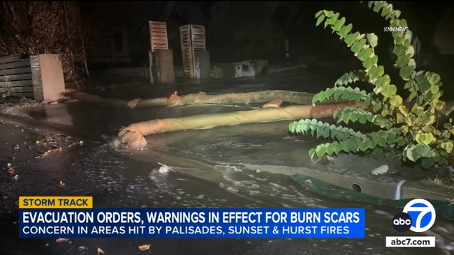
Mandatory evacuation orders are being issued for some Los Angeles residents near the Palisades Fire burn scar ahead of storms moving into SoCal.
Mandatory evacuation orders are being issued for some Los Angeles residents near the Palisades Fire burn scar ahead of storms moving into Southern California, local officials announced on Monday night.
Heavy rain is expected to pick up after midnight, and then reach its peak between 2 a.m. and noon on Tuesday. The region could also see thunderstorms, and then on-and-off showers throughout the afternoon on Tuesday.
City officials said they have identified 114 residences in the West Bureau area -- including the Pacific Palisades and Mandeville Canyon -- that will be placed under an evacuation order. Two additional residences were identified in the Valley Bureau.
The mandatory evacuation order for those residents begins at 10 p.m. Monday.
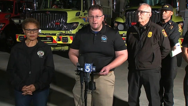
Los Angeles Police Department officers are going door-to-door in the identified evacuation areas in an effort to make contact with all residents. During a press conference that began shortly before 9 p.m., LAPD said half of the in-person door-knock notifications had been made.
"The officers are providing them a location, coordinating with the Red Cross. In West Bureau, that would be Stoner Park," LAPD Deputy Chief Emada Tingiride said. "We're hoping by 22 hundred hours this evening, all of our evacuations will be completed and our residents are able to evacuate safely."
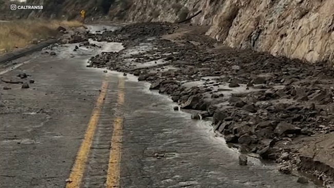
"We're worried about burn scars with no vegetation to support the hillside and then anything below, as obviously, as the rain funnels down to the streets and the main sections, homes below those become the problem," Los Angeles Fire Department Deputy Chief William Peralta said.
During the press conference, LAFD officials stressed that the department will be patrolling all burn scar areas and elsewhere throughout the city.
Heavy equipment and teams are ready to be deployed in case of a mudslide, in addition to helicopters, pilots and extra dispatch for an increase in call load.
Los Angeles Mayor Karen Bass said strike teams, rescue teams, helicopters and more are stationed throughout the city out of an abundance of caution. There are 13,000 feet of K-rail -- or temporary concrete barriers -- in debris flow areas, and sandbags are available to residents at local fire stations.
"We will be prepared for the worst and hope for the best," Bass said.
The meteorologist in charge of the National Weather Service in L.A. emphasized the importance of being overprepared.
"The cost of being underprepared is often far greater than the cost of being overprepared," said Dr. Ariel Cohen.
Cohen noted that most areas will only see rain and wind, but more severe weather, such as tornadoes, is possible.
"Most Angelenos will not experience anything more than moderate rains and gusty winds, however, the character of this particular weather system is such that a few localized spots will have the potential to experience damage coming from the stong winds, and even possibly, a couple of tornadoes, along with debris flows in the burn scar areas, and there cold be some flooding elsewhere across the region," Cohen said.
He stressed that officials can't be certain on exactly what the localized impacts will be until right before they occur at the earliest.
Angelenos are encouraged to plan ahead about what to do if the winds suddenly pick up or if you hear a severe weather warning. Cohen said residents should be indoors in a sturdy structure on the lowest floor with as many walls between you and the outside as possible. Residents should also stay away from windows.
Drivers are reminded to never travel through a flooded roadway.
Cohen also advised that Angelenos have multiple ways to receive emergency alerts, especially overnight while you are asleep.