Cleanup efforts underway across Southern California ahead of another storm

KABC logo
Last updated: Wednesday, November 19, 2025 12:14AM GMT
ABC7 Eyewitness News

Efforts are underway across Southern California to clean up downed trees, flooding and rockslides after days of rain, and the rush is on to get it all done before the next storm moves in.

Conditions will dry up somewhat for the next few days, but more rain is on the way to the region this week.

A chance for spotty, light showers will stick around Tuesday morning and afternoon.

Wednesday is expected to be mostly dry before another system arrives and brings even more showers between Thursday and Friday.

Forecasters said that system could drop another quarter to three-quarters of an inch of rain.

Here's everything you need to know about the stormy weather this week:

Carlos Granda Image
Nov 15, 2025, 3:21 AM GMT

Studio City residents brace for debris flow 1 year after damaging mudslide

Last year, there was a huge slide that sent large rocks and mud through the area. Firefighters had to help 16 residents evacuate from nine houses.

There are concerns for debris coming off the hillsides in some areas in the San Fernando Valley as heavy rain approaches Southern California.

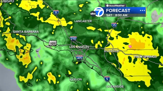
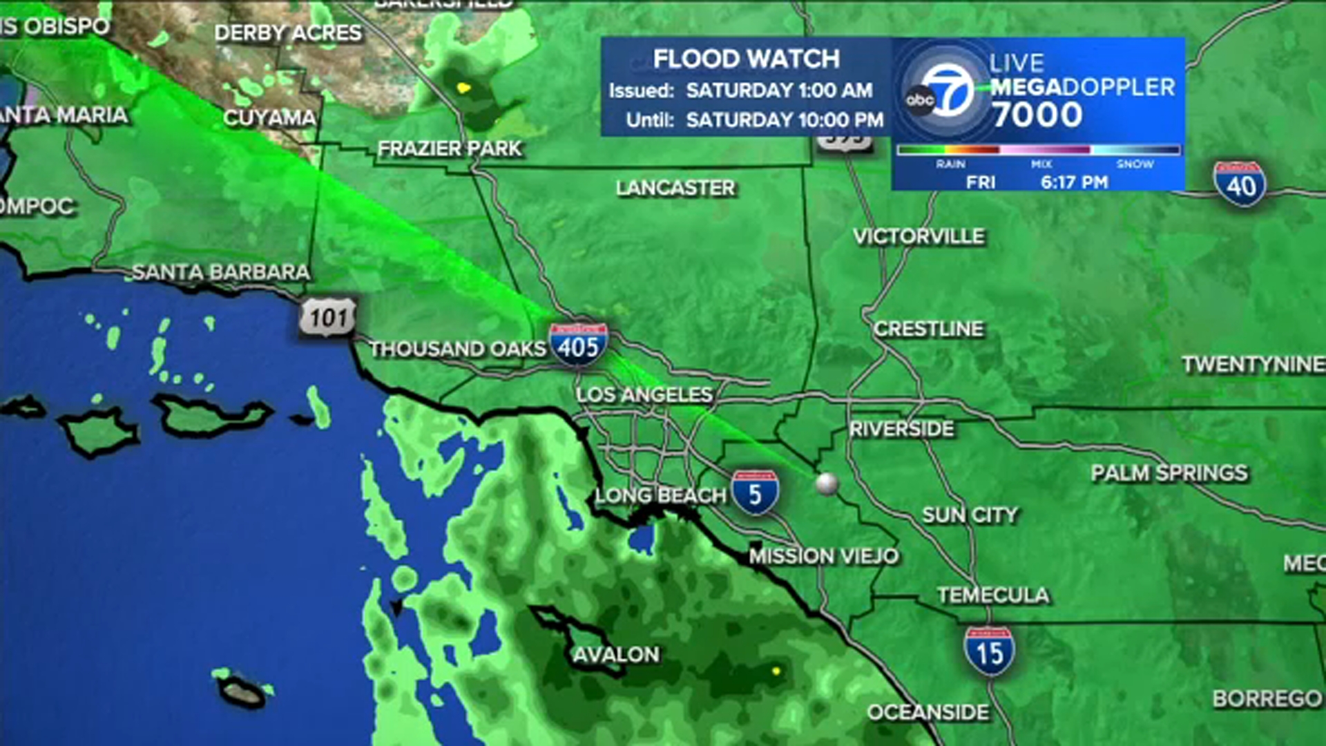
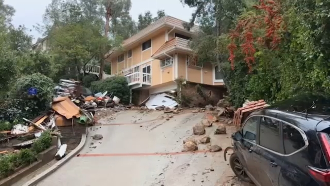
Studio City could see three to five inches of rain this weekend. About a year ago, a lot of large boulders damaged homes in a huge mudslide in the area.

"We will be concerned about the back of the hill, which is on that house next door, and then partially on our house," said Studio City resident Beverley Hogan.

The rain totals expected this weekend raise the risk of rockslides, mudslides and debris flows in the steep canyon and hillside areas.

"It is a dramatic river when it does rain for days on end," said Studio City resident Jeanne Johnson. "And so, there is actually a bit of a natural aqueduct for a lot of rain that comes down this way."

Last year, there was a huge slide that sent large rocks and mud through the area. Firefighters had to help 16 residents evacuate from nine houses.

Some of those homes are repaired, and people are rebuilding.

There are precautions in place for the incoming storm. A large plastic tarp covers part of the hillside, but below, people are still worried.

"Plastic and sandbags is all we got to protect us, and if it's a significant storm, we don't know what's going to happen," resident Rick Hogan said.

Hogan's home was yellow-tagged in last year's mudslide. He has made some repairs, but is worried it could happen again.

"We just have to hope that the best will come our way and that protection up there will be exactly that, protection. It could be against us, it could be for us. If the water comes rushing down that hill, there is nothing to stop it," Hogan said.

On the mountain slopes, rainwater can rapidly accumulate, picking up loose soil, rocks, brush and debris, sending it downhill in a fast-moving flow of mud and water. Even moderate rainfall rates can kick off a debris flow in a weakened hillside.

"This slope will come down a little bit, you know, not too much. They clean it up pretty quick. And then we always get a bunch of mud flow from here, but they clean it up," said actor Clancy Brown, a Studio City resident.

KABC logo
Nov 15, 2025, 7:59 AM GMT

Officials say LA is ready for rain, emphasize storm's unpredictable nature

At a press conference on Friday, city officials emphasized that while some Angelenos may feel no impacts at all, some areas could be hit hard.

Mayor Karen Bass, Los Angeles Fire Department Chief Jaime Moore, Los Angeles Police Chief Jim McDonnell and other city officials gathered for a press conference on Friday about how the city is preparing for incoming storms.

Dr. Ariel Cohen, the meteorologist in charge of the National Weather Service Los Angeles - Oxnard, joined them at the event to provide an update about what Angelenos should expect.

Cohen went into detail about the potential for significant flooding and debris flows across the Los Angeles region, emphasizing, "The cost of being underprepared is often far greater than the cost of being overprepared."

He said the main impacts will be felt in the next 24 to 36 hours, though due to the nature of the weather system, there are still uncertainties regarding what areas will see the most rain.

The heaviest rain will arrive overnight and stick around through Saturday afternoon. A Flood Watch is in effect for all of L.A. County through 10 p.m. Saturday.

Cohen said the heavy rain will be off and on throughout the overnight hours. He emphasized that the rain could be extremely heavy in some areas.

"While significant flooding is expected to hold off until late tonight through Saturday, we still could see some minor flooding in low-lying locations, especially along freeways, minor rock slides or mudslides through the canyons, and minor debris flows on the burn scars, including but not limited to the Palisades and Franklin burn scars," Cohen said.

After early Saturday afternoon, the weather system will begin to shift north. Cohen said the sun may even come back out in L.A. late Saturday afternoon.

Still, the energy from that sunshine could allow for additional showers later into the evening. A few light showers are also possible late Saturday night, with additional, weaker storms in the forecast for the next several days.

Cohen emphasized that while some Angelenos may feel no impacts at all, some areas could be hit hard.

"Many Angelenos may not personally experience any damaging floods, landslides or debris flows; however, the character of this weather system is such that many localized spots will have the potential to experience dangerous, life-threatening floods, landslides and debris flows. The nature of this system is such that we can't be certain of exactly when and where the impacts will strike until right before they occur at the earliest," Cohen said.

He also added that there is a risk for a small, brief and weak tornado to occur.

Bass reminded drivers to slow down and take caution when driving in the rain.

"Slow down if you're driving and plan ahead for the potential for longer travel times. Please, if you don't have to leave your home, please don't," Bass said. "The city is prepared and we are ready."

The mayor added that the crews are on standby to respond to impacts to roadways, including things like downed trees and power lines.

Many burn scar areas are under Evacuation Warnings, and an Evacuation Order is in effect from 8 p.m. Friday through 8 a.m. Sunday for 126 specific residences -- mainly near the Palisades Fire burn scar.

McDonnell said police officers have already gone door-to-door to make contact with those impacted by the Evacuation Order.

An evacuation center has been established at Stoner Recreation Center, located at 1835 Stoner Ave.

Residents can pick up sandbags at all neighborhood LAFD fire stations around the city. To see a list of fire stations that have sand available, visit lafd.org/news.

Moore added that there is increased firefighter staffing and strategically staged resources around the city, especially in the burn scar areas.

Residents are urged to call 911 for any life-threatening emergencies, and call 311 for issues like downed power lines and downed trees.

KABC logo
Nov 15, 2025, 2:54 AM GMT

Evacuation orders issued for some properties in burn scar areas at high risk of mudslide damage

Evacuation orders will go into effect at 8 p.m. Friday through Sunday at 8 a.m. for 126 specific residences that are at higher risk for mud and debris flow impacts in the following burn scar areas:

  • Canyon
  • Bethany
  • Eaton
  • Palisades
  • Hurst
  • Kenneth
  • Sunset
  • Lidia
  • Franklin
  • Bridge

Most of the properties under the evacuation order are situated in the Palisades Fire burn zone.

LAPD Chief Jim McDonnell said police officers have already gone door-to-door to make contact with those impacted by the Evacuation Order.

An evacuation center has been established at Stoner Recreation Center, located at 1835 Stoner Ave.

The same burn scar areas are under an evacuation warning through Friday at 8 p.m.

Evacuation orders were issued for specific properties in the burn areas above.
Dallas Raines Image
Nov 15, 2025, 3:52 AM GMT

Latest look at the SoCal storm and what's next

Heavy rain has started to fall in some parts of Southern California as subtropical moisture moves through the region.

Heavy rain has started to fall in some parts of Southern California as subtropical moisture moves through the region, threatening to bring flooding and possible mudslides to areas burned by wildfires.

The heaviest of the rain is expected overnight through Saturday afternoon, though the wet weather will last through the weekend and possibly into next week when a third, though much lighter, storm arrives on Monday.

Areas impacted by recent wildfires, such as Altadena and Pacific Palisades, are estimated to get more than 2.5 inches of rain by Saturday night.

A Flash Flood Watch is in place for the entire region from Saturday at 1 a.m. through Saturday at 10 p.m.