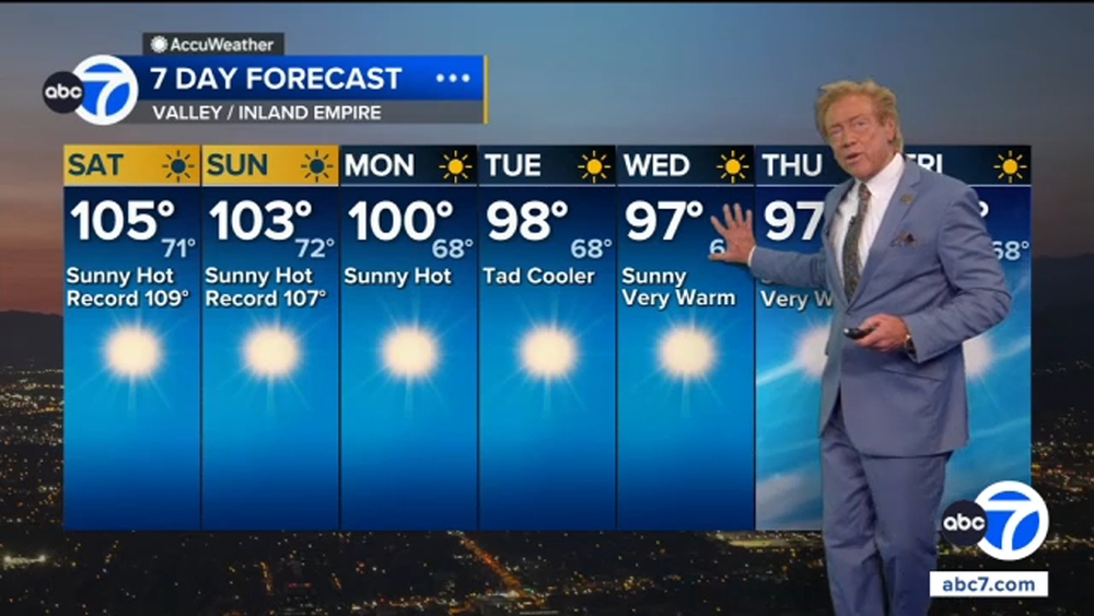
Hughes Fire map shows evacuation zones near Castaic Lake


CASTAIC, Calif. (KABC) -- Mandatory evacuations were issued Wednesday in the Castaic area due to the fast-spreading Hughes Fire.
CAL FIRE's map shows the evacuation zones.
Mandatory evacuation orders were issued for the following zones, according to CAL FIRE:
CAS-BITTERCANYON
CAS-CASTAICLAKE
CAS-CHARLIECANYON
LAC-E008
LAC-E016.
Evacuation warnings were issued for the following zones:
CAS-BISCAILUZ
CAS-CAMBRIDGE
CAS-GOLDENSTATE
CAS-GREENHILL
CAS-HASLEY
CAS-HILLCREST
CAS-INDUSTRY
CAS-LIVEOAK
CAS-OAKCANYON
CAS-PARADISERANCH
CAS-RIDGE
CAS-ROMERO
CAS-SLOAN
CAS-VALVERDE
GOR-E004
GOR-HUNGRYVALLEY
LAC-E005
LAC-E009-B
LAC-E011-A
LAC-E017
LAC-E018
LAC-E029
LAC-E030
LAC-FRANCISQUITO
SCL-BLACKPINE
SCL-CALEX
SCL-DECORO
SCL-KELLYJOHNSON
SCL-MOUNTAINVIEW
SCL-PACIFICCREST
SCL-RANCHOTESORO
SCL-REYESABODE
SCL-REYESADOBE
SCL-RIONORTE
SCL-RYE
SCL-TESORODELAVALLE
SCL-WESTHILLS
SLC-REYESADOBE
SLC-STERLING
Road closures
- Ridge Route Rd at Lake Hughes
- Ridge Route Rd at Templin Hwy
- Lake Hughes at Pine Cyn
- Dry Gulch at San Francisquito Cyn Rd
- I-5 NB at Parker Rd Off Ramp and I-5 NB at Lake Hughes Rd off ramp will be shut down.
Evacuation shelters
- Evacuation center: College of the Canyons East Gym at 26455 Rockwell Canyon Road, Santa Clarita, CA 91355