Live updates: Storm brings flooding, stalled cars near Burbank airport

KABC logo
Last updated: Friday, February 20, 2026 1:04PM GMT
ABC7 Eyewitness News

LOS ANGELES (KABC) -- You may want to keep the rain boots and umbrellas out as the third storm to hit Southern California this week moves into the region Thursday morning, bringing more rain to areas previously affected.

Powerful thunderstorms, wind and rain battered the region just days ago, toppling over trees and leading to water rescues.

Get the latest storm timeline and developments from across the region below:

Brianna Ruffalo  Image
Feb 19, 2026, 8:08 PM

SoCal will soon get a break from wet weather

The third storm of the week is quickly moving into Southern California, bringing more rain and snow, but the region will soon get a break from the wet weather.

Light to moderate rail will continue to move east, with heavy downpours possible at times. Cold temperatures and gusty conditions with potentially damaging winds will remain even after the rain stops.

The widespread rain will begin to taper off by the early afternoon hours as it moves into the Inland Empire.

The third storm of the week is quickly moving into Southern California, bringing more rain and snow, but the region will soon get a break from the wet weather.
KABC logo
Feb 15, 2026, 3:02 AM GMT

Evacuation warning issued for possible debris flows in LA burn scar areas

The city of Los Angeles issued evacuation warnings for people living in burn scar areas, after a flood watch was issued for a wide swath of Los Angeles County from Monday morning through Monday evening. Rock and mud slides are possible near steep terrain, and debris flows are possible on burn scars.

Mayor Karen Bass warned residents in those areas to take precautions and be prepared for potential emergency warnings.

"Ahead of heavy rain forecasted this week, first responders, Public Works crews, and city personnel are taking action to keep Angelenos safe and will be ready to respond to any potential impacts," Bass said in a statement late Saturday. "This is likely to be another significant rain event. All Angelenos -- especially those in burn scar areas -- are encouraged to follow official guidance, use caution on the roads, plan ahead, and stay informed."

The warning goes into effect at 9 p.m. on Sunday and lasts through 9 a.m. Tuesday.

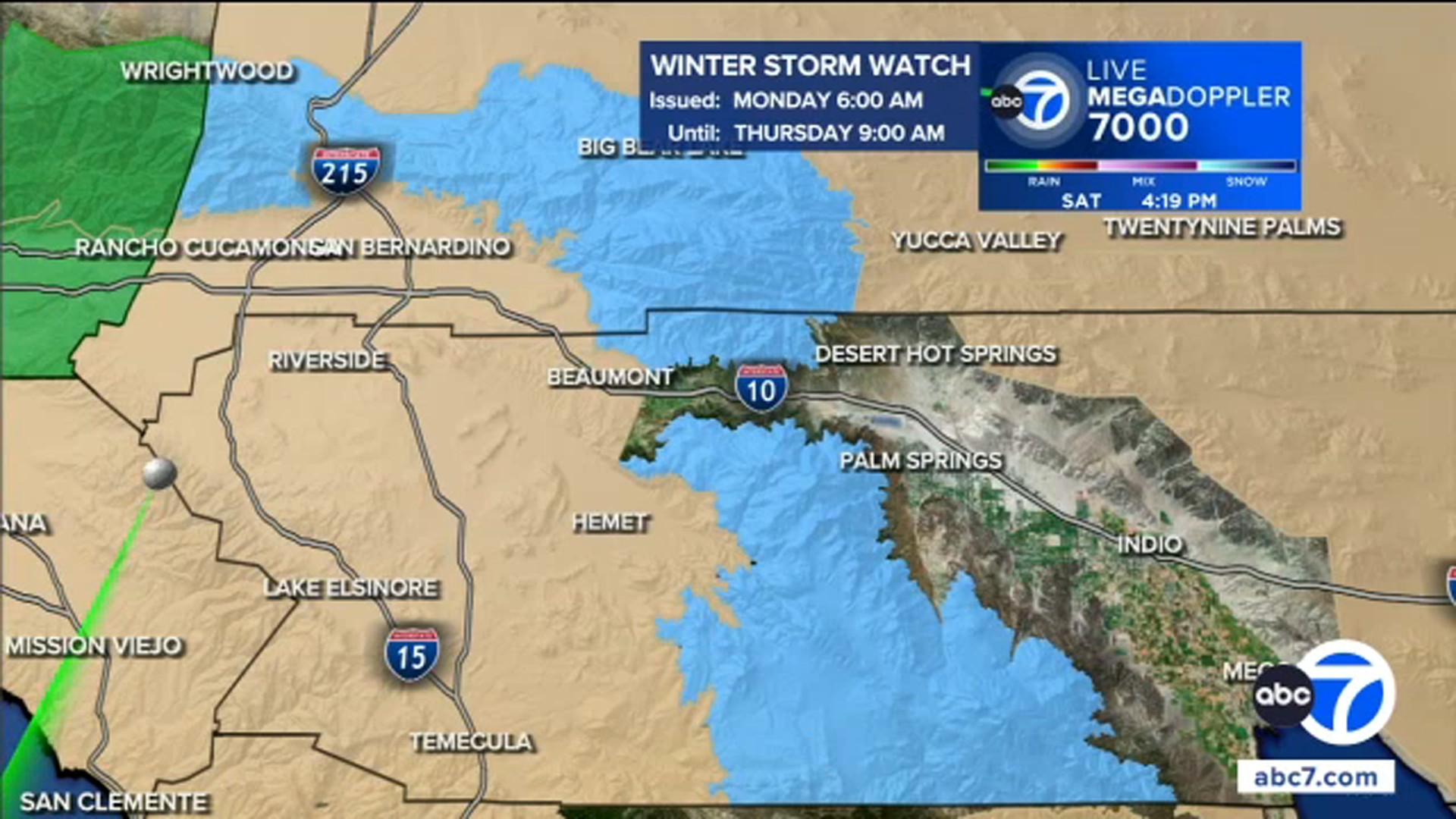
See the map of impacted areas here:

KABC logo
Feb 15, 2026, 3:13 AM GMT

Stretch of Topanga Canyon Boulevard to close ahead of storm

Storm preparations are already happening ahead of the round of storms set to arrive on Monday.

Caltrans will close a 3.5-mile stretch of Topanga Canyon Boulevard starting at 10 p.m. on Sunday from Pacific Coast Highway up to Grand View Drive.

This has become a common occurrence before recent storms due to fear of mud and debris slides in the Palisades Fire burn zone.

The closure is expected to last through at least Tuesday morning.

KABC logo
Feb 15, 2026, 3:13 AM GMT

Flood Watch issued for much of Southern California beginning Monday morning

A Flood Watch is in place for parts of Los Angeles, Ventura, San Luis Obispo and Santa Barbara counties from 9 a.m. to 9 p.m. on Monday.

Rock and mud slides are possible near steep terrain, and debris flows are possible on burn scars.

KABC logo
Feb 15, 2026, 3:13 AM GMT

Winter Storm Watch begins Monday for mountain regions with snow on the way

A Winter Storm Watch is in place for the higher elevation mountain regions, including the northern Ventura County Mountains and eastern San Gabriel Mountains, from 6 a.m. Monday through 9 a.m. on Thursday.