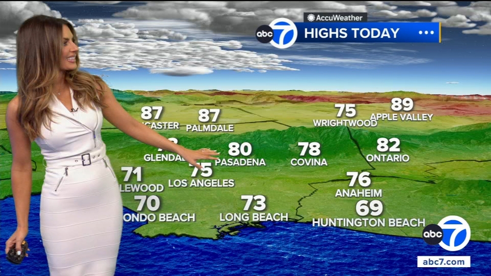
LA County sees flash flood, evacuation warnings as storm brings more rain


LOS ANGELES (CNS) -- Steady rain fell across much of Los Angeles County Monday as a three-day storm arrived, accompanied by numerous flash flood warnings and at least one evacuation warning as authorities urged caution on area roads.
Forecasters reported rainfall rates of 0.10 to 0.25 inch per hour early Monday, but nearly a half-inch per hour in the Santa Monica Mountains, which had already received 3 inches of rain by Monday morning.
WATCH: SoCal storm creates messy road conditions for drivers

Flash flood, mudslide and evacuation warnings across Southern California
Flash flood warnings and flood advisories were in affect through Wednesday morning over much of Los Angeles County, and the National Weather Service said "there have been many reports of rockslides, mudslides and flooded roads'' Monday in Santa Barbara, Ventura and Los Angeles counties.
A flash flood warning was in effect until 6 p.m. Monday for the Santa Monica Mountains east to the Hollywood Hills and Griffith Park as well as surrounding Malibu and the San Fernando Valley.
Los Angeles officials said on Monday afternoon that multiple city departments were working together to close the Sepulveda Basin "for the safety of pedestrians and motorists."
An evacuation warning was issued along Santa Maria Road north of Topanga Canyon Boulevard, southeast of Calabasas, due to possible mud/debris flows from 9 a.m. Monday through 9 a.m. Wednesday.
LA County Public Works officials issued a "phase 2 debris flow forecast" for the Land Fire burn area east of Sun Valley. The alert will be in effect from 9 a.m. Monday to 9 a.m. Wednesday, according to the Los Angeles Fire Department, which said moderate flooding and mudflow/sediment deposition should be anticipated in the area of McDonald Creek, Del Arroyo Drive and La Tuna Canyon Road.
"If conditions worsen, evacuation orders may be issued and evacuation sites will be identified," the LAFD said. "Take action now to be ready to quickly evacuate if you live on the streets along La Tuna Canyon Road with the borders of Horse Haven Street to the north, Martindale Avenue to the east, Penrose Street to the south, and Ledge Avenue to the west."
Farther south, a portion of Benedict Canyon Road was restricted to local access only due to a collapsing roadway. The "soft closure" was in effect from Mulholland Drive to Hutton Drive, with Deep Canyon Drive suggested as an alternate route.
A portion of Mulholland Drive remained closed to through traffic between Skyline Drive and Bowmont Drive due to severe road damage at four locations. That closure was expected to last weeks, officials said.
The Skirball Center Drive/Mulholland Drive off-ramp from the northbound 405 Freeway was closed until further notice due to a sinkhole. Other road closures due to flooding or debris were the Interstate 5 south transition to the southbound Harbor (110) Freeway, and Second Street between Vignes Street and Garey Street.
In Rancho Palos Verdes, homeowners were dealing with reports of accelerated land movement and fears of further erosion. Los Angeles County Supervisor Janice Hahn urged Gov. Gavin Newsom to visit the area and observe the situation for himself.
"We need the governor's help," Hahn said in statement. "It is my understanding that the city of Rancho Palos Verdes will be asking the governor to declare a state of emergency for the Greater Portuguese Bend Landslide Complex. I think if the governor came here and saw the buckling streets, the homes sinking and cracking apart, and the historic Wayfarers Chapel on the verge of collapsing, he would understand the urgency of this request. This is a crisis that is getting worse by the day, and I urge Governor Newsom to visit us and see it with his own eyes."
Flood fears are heightened due to the region's already soaked terrain from storms earlier this year, prompting Los Angeles city officials to put comprehensive measures in place to manage the effects of the latest storm.
The city's Emergency Operations Center was activated to a Level 2 to monitor the impacts and coordinate the resources needed to respond to storm-related problems.
"Over the past week, the City has worked to repair more than 4,000 potholes, reinforce hills that are at risk of mudslides and prevent power outages by making repairs to underground equipment and vaults that had flooded during the previous storm," Mayor Karen Bass said Sunday on X.
As of 6 a.m. Monday, the city had responded to three reports of fallen trees and branches and four reports of mudslides, according to Bass' office.
The Los Angeles Department of Water and Power was reporting no significant outages, but a water main break in Hollywood was impacting 20 customers and was expected to be resolved by noon, officials said.
The city and county of Los Angeles activated the Augmented Winter Shelter Program to provide additional shelter options for people living on the streets. Both programs began Friday. Officials said the county's last intake will be Tuesday, and the city's last intake will be Wednesday.
The Los Angeles Homeless Services Authority oversees and operates the program.
Newsom activated the State Operations Center to help coordinate state, local and federal response to the storm.
How much rain is expected from the SoCal storm?
Forecasters said totals of 2 to 5 inches were expected across the coasts and valleys, and 4 to 8 inches across south and southwest-facing mountain slopes and foothills. Peak rainfall rates of 0.5 to 1 inch per hour are likely.
"A very strong 170 mph jet streak and modest lapse rates will support a slight chance of thunderstorms building into the region around the same time frame," the NWS said. "Any thunderstorms or convective showers may support dangerous cloud-to-ground lightning, gusty and damaging winds, and a brief water spout or tornado."
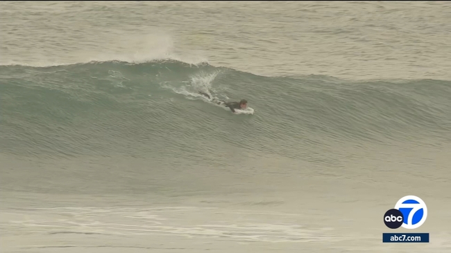
High surf and snow expected with Southern California storm
The storm is also expected to produce high surf and gusty winds in the mountains and foothills. Snow levels during the peak of the storm will be about 8,000 feet, lowering to around 7,000 feet Monday or Tuesday, with 5 to 10 inches possible between 6,500 and 8,000 feet.
A high surf advisory will be in effect through 10 p.m. Tuesday in coastal Orange County, with waves up to 10-15 feet expected, and a coastal flood advisory is in effect until 9 a.m. Tuesday at Catalina Island.
A wind advisory was in effect until 6 p.m. Monday in the San Gabriel Mountains and the Antelope Valley, where gusts of 56 mph were expected.
When will the rain end?
Dry weather with warming temperatures is expected to return Thursday and Friday, before another possible bout of light rain next weekend.