Atmospheric river moves into SoCal, bringing heavy rain and raising risk of flooding


LOS ANGELES (KABC) -- The first of two storms expected to batter the Southland began bearing down on the region Thursday, with significant rainfall and snowfall expected Thursday morning and well into the afternoon -- ahead of more dramatic downpours anticipated early next week.
Read more: Get the latest forecast here
Storm dumps heavy snow at ski resorts in San Bernardino County
The storm dumped heavy snow overnight in Wrightwood and Running Springs amid powerful winds, which subsided as the sun came up and revealed a blanket of fresh powder at Mountain High Resort and Snow Valley Mountain Resort.
Gleeful skiers and snowboarders took to the slopes as crews worked to clear snow from roadways in the area.
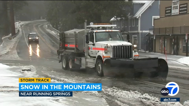
A winter storm warning was in effect and is scheduled to last until 10 p.m. Thursday in the eastern San Gabriel Mountains, including Mount Wilson, Mount Baldy, Wrightwood and the Angeles Crest Highway.
As much as 18 inches of snow could fall above 7,000 feet in the area, with 6 inches possible at 6,000 feet and 3 inches at elevations as low as 4,500 feet. The snow will be accompanied by winds gusting at up to 55 mph, according to the NWS.
Cities along Southern California coast see several inches of rain
After several hours an atmospheric river storm moved into Southern California, areas near the coast saw nearly 3 to 4 inches of rain.
As of 9:45 a.m., here are rain totals from some coastal cities:
- Harbor City: 3.8 inches
- Rolling Hills: 3.7 inches
- Manhattan Beach: 3.3 inches
- Torrance: 3 inches
- Pacific Palisades: 2.8 inches
- Redondo Beach: 2.8 inches
Live radar: abc7.la/LiveMEGADOPPLER
In comparison, downtown Los Angeles got 1.92 inches of rain.
Man rescued from Costa Mesa storm channel
A man trapped in a Costa Mesa storm channel filled with rainwater was rescued Thursday morning, the Orange County Fire Authority said.
The agency posted video the rescue on its X account, showing the swift water rescue team had navigating a raft under a roadway overpass to reach the victim.
Watch: See video of the rescue here
Storm forces part of Pacific Coast Highway to close
The northbound and southbound lanes of the Pacific Coast Highway in Orange County are closed from Seapoint Street to Warner Avenue, according to Caltrans.
Flooding, caused by the heavy rain from the storm, prompted officials to close the roadway, agency posted on X at 6:24 a.m.
Drivers can track real-time road closures with this Caltrans interactive map.
Download the ABC7 app for weather alerts: Click here for iOS devices | click here for Android devices. If you have the app, turn on push notifications and personalize the app. Click on My News from the bottom menu, then star the topics you'd like to follow and tap Done.
Drivers brave a rain-soaked commute in Los Angeles, Orange counties
The Southland will likely see the brunt of the rainfall throughout morning rush hour, with the strongest downpours expected to occur during a one- to three-hour period "when the primary frontal band moves through," according to the National Weather Service.
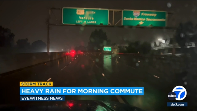
Forecasters predicted rain rates of about a half-inch per hour, with some localized areas receiving 0.8 inches per hour. Coastal and valley areas are expected to receive 1 to 2 inches of rain during the Thursday storm, with foothills and mountains potentially seeing 3 to 5 inches.
2nd atmospheric river storm on the way
The "Pineapple Express" - called that because its long plume of moisture stretched back across the Pacific to near Hawaii - will be followed by an even more powerful storm on Sunday, forecasters said.
The California Governor's Office of Emergency Services activated its operations center and positioned personnel and equipment in areas most at risk from the weather.
Brian Ferguson, Cal OES deputy director of crisis communications, characterized the situation as "a significant threat to the safety of Californians" with concerns for impact over 10 to 14 days from the Oregon line to San Diego and from the coast up into the mountains.
"This really is a broad sweep of California that's going to see threats over the coming week," Ferguson said.
Last winter, California was battered by numerous drought-busting atmospheric rivers that unleashed extensive flooding, big waves that hammered shoreline communities and extraordinary snowfall that crushed buildings. More than 20 people died.
The second storm in the series has the potential to be much stronger, said Daniel Swain a climate scientist at the University of California, Los Angeles.
Models suggest it could intensify as it approaches the coast of California, a process called bombogenesis in which a spinning low-pressure system rapidly deepens, Swain said in an online briefing Tuesday. The process is popularly called a bomb cyclone.
The new storms come halfway through a winter very different than a year ago.
Despite storms like a Jan. 22 deluge that spawned damaging flash floods in San Diego, the overall trend has been drier. The Sierra Nevada snowpack that normally supplies about 30% of California's water is only about half of its average to date, state officials said Tuesday.
The Associated Press and City News Service contributed to this report.