Rainfall totals: Hilary breaks SoCal records; over 1 foot of rain hits San Bernardino County | LIST
Rainfall totals have reached 13.5 inches in San Bernardino Co. Palm Springs saw more than 3 inches, breaking a seasonal record.


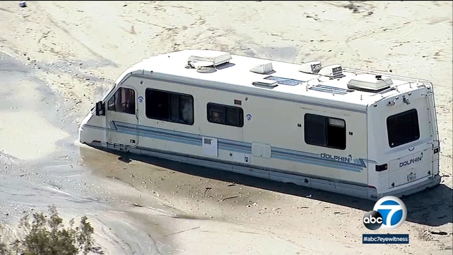
LOS ANGELES (KABC) -- Once a Category 4 hurricane, Hilary tore through Southern California with historic rainfall on Sunday, flooding roads and knocking out power.
Rainfall totals from Hilary have reached 13.5 inches in San Bernardino County, and 11.7 inches in the mountains of Riverside County.
LIST: School closures in Southern California
Los Angeles County recorded over 7 inches of rain. Downtown L.A. recorded 2.48 inches of rainfall on Sunday, making it the wettest August day ever in that area, according to the National Weather Service.
Palm Springs saw more than 3 inches, which broke the desert city's all-time daily summer rain record.
San Diego saw 1.82 inches of rain, making Sunday the wettest August day on record in the city, according to ABC News. Plus, Escondido and Cuyamaca saw 2.66 inches and 4.11 inches, respectively, marking the wettest month of August for those regions.
MORE: Coachella Valley inundated with mud, drivers trapped in flash floods
Here are the two-day precipitation totals, according to the National Oceanic and Atmospheric Administration. All measurements in inches.
Los Angeles County Coast & Metro
Data released at 7:15 a.m. PT
- Hollywood Reservoir: 4.92
- Beverly Hills: 4.80
- Leo Carrillo: 4.39
- Bel Air: 4.14
- Culver City: 3.65
- Santa Monica: 3.56
- La Downtown: 2.99
- Long Beach: 2.62
- La Airport: 2.54
- Redondo Beach: 2.47
- Hawthorne: 2.24


San Fernando Valley
Data released at 7:15 a.m. PT
- Van Nuys: 4.70
- La Canada Flintridge: 4.52
- Northridge: 4.47
- Calabasas: 3.98
- Porter Ranch Raws: 3.96
- Agoura Hills: 3.95
- San Rafael Hills: 3.81
- Burbank: 3.56
- Canoga Park: 3.51
- Chatsworth Reservoir: 3.02
- Hansen Dam: 2.29
- San Gabriel Valley
- Morris Dam: 5.76
- East Pasadena: 5.74
- Eagle Rock Reservoir: 4.70
- Sierra Madre: 4.45
- Claremont: 4.04
- La Verne: 4.01
- Alhambra: 3.60
- Whittier: 2.81
- Pasadena: 2.40
- Mt Olive High School: 1.96

Santa Clarita Valley
Data released at 7:15 a.m. PT
- Saugus: 6.46
- Newhall: 5.71
- Castaic Junction: 5.47
- Del Valle: 5.26
- Castaic.: 4.51
Catalina Island
Data released at 7:15 a.m. PT
- Catalina Island Raws: 2.91
- Avalon Harbor: 1.85

Los Angeles County Mountains
Data released at 7:15 a.m. PT
- Mount Wilson: 8.56
- Lewis Ranch: 7.04
- Leona Valley Fire Station: 6.97
- Crystal Lake: 6.97
- Cogswell Dam: 6.69
- Santa Anita Dam: 6.53
- San Gabriel Dam: 5.98
- Mt Baldy: 5.84
- Sierra San Antonio Medical Plaza: 5.84
- Big Dalton Dam: 5.67
- Chilao South: 5.16
- Mill Creekl 5.14
- Inspiration Point: 5.08
- West Fork Heliport: 4.92
- Camp 9: 4.86
- Whitaker Peak: 4.40
- Chilao: 4.37
- Tanbark: 4.34
- Warm Springs Camp: 4.10
- Warm Springs: 4.08
- Opids Camp: 3.42
- Hungry Valley: 3.38
- San Antonio Dam: 2.92
- Sandberg: 1.54
Santa Monica Mountains
Data released at 7:15 a.m. PT
- Stunt Ranch: 5.08
- Sepulveda Cyn At Mulh: 4.91
- Topanga: 4.74
- Monte Nido: 4.65
- Lechuza: 4.03
Antelope Valley
Data released at 7:15 a.m. PT
- Lake Palmdale: 5.98
- Valyermo: 5.65
- Poppy Park: 4.29
- Palmdale: 3.94
- Saddleback Butte: 3.24
- Lancaster: 2.16
Orange County Coastal Areas
Data released at 4:47 a.m. PT
- Coto de Caza: 3.07
- Alameda Storm Channel: 2.92
- Orange Co Reservoir: 2.78
- Lower Silverado: 2.76
- Brea Olinda: 2.68
- Brea: 2.64
- Santa Ana Engineering: 2.56
- Garden Grove: 2.48
- Pico Retarding Basin: 2.48
- Yorba Reservoir: 2.44
- San Juan Capistrano: 2.44
- Bell Canyon: 2.41
- Gilbert Retarding Basin: 2.40
- Fullerton Creek: 2.36
- Fullerton Dam: 2.32
- Lower Oso Creek: 2.28
- East Garden Grove/Wintersburg: 2.28
- Carbon Canyon Dam: 2.22
- Laguna Niguel Park: 2.20
- San Juan Guard: 2.17
- Bee Canyon: 2.09
- Huntington Beach: 2.09
- Laguna Audubon: 2.08
- Costa Mesa: 2.00
- Villa Park Dam: 1.97
- Westminster Channel: 1.93
- Anaheim Hills: 1.85
- Yorba Park: 1.82
- El Modena-Irvine: 1.81
- Villa Park Reservoir: 1.74
- Lane Channel: 1.73
- Santa Ana Delhi Chnl: 1.73
- Laguna Canyon Repeater: 1.69
- San Diego Creek @ Campus: 1.69
- San Diego Ck @ Culver: 1.65
- Peters Canyon Wash:1.58
- Corona Del Mar: 1.57
Ventura County Coastal
Data released at 7:15 a.m. PT
- California State University Channel Islands: 4.17
- Saticoy: 2.52
- Oxnard: 1.63
- Ventura: 1.44
- Oxnard Civic Center: 1.08
- Silverstrand Beach: 0.75
- La Conchita: 0.48
Ventura County Coastal Valleys
Data released at 7:15 a.m. PT
- Rocky Peak: 4.33
- Deals Flat: 3.81
- Circle X Ranch: 3.78
- South Mountain: 3.77
- Moorpark: 3.75
- Cheeseboro: 3.52
- Miller Ranch: 3.42
- Thousand Oaks: 3.35
- Simi Valley: 3.34
- Westlake Village: 3.19
- Newbury Park: 3.00
Ventura County Interior Valleys
Data released at 7:15 a.m. PT
- Piru: 4.71
- Lake Piru: 4.70
- Santa Paula: 3.52
- Sulphur Mountain: 2.47
- Harmon Canyon ..... 2.19
- Stewart Canyon: 1.65
- Ojai: 1.56
- Red Mountain: 1.18
- Station Canyon: 0.90
- Fillmore: 0.36
- Fagan Canyon: 0.04
Ventura County Mountains
Data released at 7:15 a.m. PT
- Last Chance: 3.31
- Lockwood Valley: 2.95
- Chuchupate: 2.57
- Nordhoff Ridge: 2.52
- Sycamore Canyon: 2.17
- Ortega Hill: 2.04
- Rose Valley: 1.97
- Rose Valley Raws: 1.75
- Apache Canyon: 1.38
- Matilija Canyon: 1.30
- White Ledge Peak: 1.30
- Old Man Mountain: 1.22
- Matilija Dam: 1.17
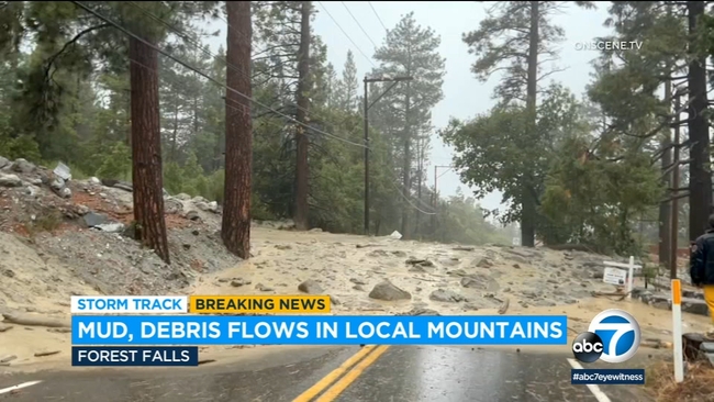
MORE: Mud, debris flows inundate San Bernardino mountains amid Hilary
Santa Ana Mountains
Data released at 4:47 a.m. PT
- Upper Harding Canyon: 4.53
- Santiago Peak: 4.17
- Horsethief/Rice Canyon: 4.09
- Upper Silverado Canyon: 4.09
- Santa Rosa Plateau: 3.90
- Holy Jim Canyon: 3.35
- Leach/Dickey Canyon: 3.31
- Indian Canyon: 3.23
- El Cariso: 3.11
- McVicker Canyon: 3.07
- El Cariso Raws: 2.89
- Silverado Motorway: 2.76
- Modjeska Canyon: 2.71
- Sylvan Meadows: 2.14
- Fremont Canyon Raws: 2.01
The Inland Empire (San Bernardino County)
Data released at 4:47 a.m. PT
- Devore Fire Station: 4.24
- Demens Creek Debris Basin: 3.31
- Chino Airport: 2.55
- Gilbert Street, North San Bernardino: 2.40
- San Bernardino: 1.69

The Inland Empire (Riverside County)
Data released at 4:47 a.m. PT
- Cabazon Raws: 3.34
- Temecula: 2.76
- Murrieta Ck At Tenaja: 2.56
- Beaumont Raws: 2.52
- Norco: 2.48
- Temescal Forest Service Station: 2.36
- Railroad Canyon Dam: 2.32
- North Elsinore: 2.20
- Riverside South: 2.16
- Pigeon Pass Dam: 2.16
- Potrero Canyon: 2.13
- Clark Raws: 2.05
- Lake Matthews Raws: 2.04
- Riverside - March Air Reserve Base: 2.02
- Perris Fire Department: 1.97
- Riverside Airport: 1.96
- Prado Dam: 1.94
- Beaumont: 1.93
- Moreno-Clark: 1.89
- San Jacinto North: 1.81
- Lake Matthews: 1.52
- French Valley Airport: 1.36

Riverside County Mountains
Data released at 4:47 a.m. PT
- Mount San Jacinto: 11.74
- Snow Creek in Idyllwild: 7.83
- Upper Tahquitz Creek: 6.22
- Pine Cove Rocky Point: 3.33
- Vista Grande Raws: 3.32
- Allandale: 3.15
- Poppet Flat Raws: 2.84
- Beaumont (Near Bogart Park): 2.55
- Banning Bench: 2.44
- Vista Grande: 2.44
- Keenwild Raws: 2.40
- Thomas Mountain: 2.11
- Anza Raws: 2.11
- Sage Raws: 1.91

Coachella Valley
Data released at 4:47 a.m. PT
- Whitewater Trout Farm: 6.61
- Morongo Valley: 5.75
- Palm Desert: 3.82
- Wide Canyon Dam: 3.78
- Cathedral Canyon: 3.61
- Desert Hot Springs: 3.35
- Palm Springs Airport: 3.23
- Lower Tahquitz Creek: 2.91
- Cactus City: 2.64
- Thermal Airport: 2.35
- Kent Sea Tech (Mecca): 2.29
- Thousand Palms: 1.66

San Bernardino County Mountains
Data released at 4:47 a.m. PT
- Raywood Flats: 11.73
- Heart Bar: 9.67
- Lytle Creek Raws: 9.44
- Middle Fork Lytle Creek: 8.84
- Heaps Peak Raws: 8.46
- Bernina Drive: 8.11
- Mormon Rock Raws: 6.30
- Wrightwood: 6.23
- Mt. Baldy: 5.80
- Big Bear Lake Dam: 4.40
- Converse Raws: 4.10
- Manzanita Flats: 3.23
- Fawnskin Raws: 3.21
- Big Bear Lake: 2.88
- Big Pine Flat Raws: 2.54
Apple and Lucerne Valleys
Data released at 4:47 a.m. PT
- Mojave Forks Dam: 5.40
- El Mirage Raws: 2.88
- Hesperia: 2.14
- Means Lake Raws: 1.67
- Granite Mountain Raws: 1.32
This is a developing story. Check back here for new developments.
ABC News contributed to this report.