SoCal braces for rain, snow and wind as cleanup from previous storm system continues in some areas


LOS ANGELES (KABC) -- Another bout of rain and mountain snow are set to arrive in Southern California beginning Friday night, even as cleanup operations from the most recent storm continue in some areas.
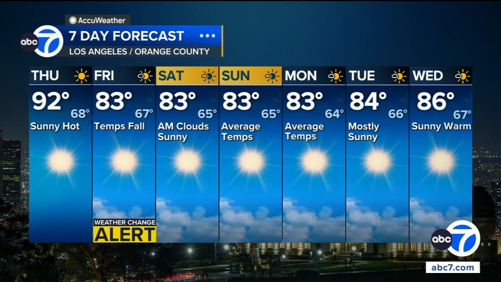
While the brunt of the storm is likely to primarily impact areas north of Los Angeles County, will nonetheless have to cope with light rain, some gusty winds and below-normal temperatures.
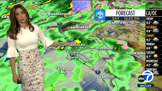
"While central and northern California will see a big rain and snow impacts, southwest California will be on the fringes of the system -- but not without some threats," according to the National Weather Service. "As such, Friday through Saturday will be characterized by many hours of steady light rain and mountain snow along with gusty southwest winds, with a decreasing trend on Sunday. The peak of this storm for our area will be on Saturday."
At least nine Lake Tahoe ski resorts closed and visitors to Yosemite National Park were told to urgently leave Friday as California's most powerful storm of the season bore down on the Sierra Nevada, where residents were urged to take shelter as they prepared for up to 10 feet of snow in some areas.
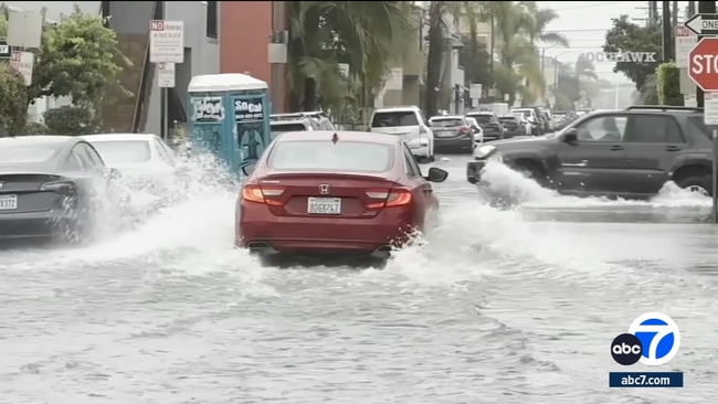
Forecasters said the overall storm system will likely drop between a half-inch and an inch of rain in most parts of the greater Los Angeles area.
"While roads and outdoor events will be impacted, and creeks will see healthy flows, flooding impacts with these totals and rates should be limited to the areas most vulnerable to mudslides," according to the weather service.
Some roads are set to be closed as a precaution. Malibu Canyon Road, which was shut down due to a major landslide last week, is scheduled to be closed again at 7 p.m. Friday between Piuma Road and Pacific Coast Highway. The road may reopen at 6 a.m. Monday if conditions allow, officials said.
As much as 12 inches of snow could fall at mountain elevations above 6,500 feet, with as much as 6 inches possible as low as 5,500 feet. There is only a slight chance of accumulating snow on the 5 Freeway through the Tejon Pass.
The storm system will also bring gusting winds to some mountain areas, particularly in the San Gabriel Mountains and the Antelope Valley.
"Probably the biggest thing with this storm is the wind," said National Weather Service meteorologist Ryan Kittell. "There'll be a lot of wind, especially up in the mountains and deserts."
A high wind watch will be in effect in the Antelope Valley foothills and the western San Gabriel Mountains from Friday night through Sunday afternoon, with forecasters anticipating winds of up to 35 mph, gusting as high as 60 mph.
For the rest of the Antelope Valley, a wind advisory will be in place from 10 p.m. Friday through 1 p.m. Sunday, with similar wind speeds anticipated.
In the eastern San Gabriel Mountains, a winter storm watch will be in effect from Friday evening through Sunday morning, thanks to the possibility of higher-elevation snow accumulations and winds gusting up to 65 mph.
The storm should move out of the area by Sunday, with another round of light rain possible by Wednesday.
The Associated Press and City News Service contributed to this report.